Geographic Region: FRANCE
Feature: RHONE VALLEY, ALPS, CONTRAILS
|
Geographic Region: FRANCE Feature: RHONE VALLEY, ALPS, CONTRAILS |
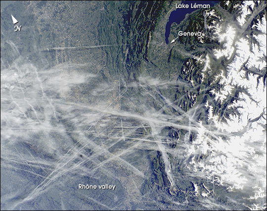 |
| This digital photograph taken through the windows of the International Space Station on May 15, 2002, shows condensation trails over the Rhone Valley in the region west of Lyon. Condensation trails--or contrails--are straight lines of ice crystals that form in the wake of jet liners where air temperatures at altitude are lower than about -40degC. Newer contrails are thin whereas older trails have widened with time as a result of light winds. Because of this tendency for thin contrails to cover greater areas with time, it is estimated that these "artificial clouds" cover 0.1% of the planet's surface. Percentages are far higher in some places such as southern California, the Ohio River Valley and parts of Europe, as illustrated here. The climatic impact of such clouds is poorly understood. In an unprecedented experiment following the September 11 grounding of all aircraft in the United States, researchers reported in the August 8 issue of Nature that temperatures in areas usually affected by contrail blankets fluctuated higher and lower during the contrail-free period. Despite this dramatic conclusion, it is nevertheless too early to know whether contrails produce a net warming or cooling of the atmosphere. Whereas cirrus clouds seem to have a net warming effect, contrails are denser and thus may produce the opposite effect. References: Travis, D. J., Carleton, A. M. and R. G. Lauritsen. 2002. Contrails reduce daily temperature range. Nature 418:601. 9/11 study: Air traffic affects climate (CNN) (//www.cnn.com/2002/TECH/science/08/07/contrails.climate/index.html) |
| Images: | All Available Images Low-Resolution 83k |
|
| Mission: | ISS004 |
|
| Roll - Frame: | E - 11807 |
|
| Geographical Name: | FRANCE |
|
| Features: | RHONE VALLEY, ALPS, CONTRAILS |
|
| Center Lat x Lon: | 46.0N x 6.0E |
|
| Film Exposure: | N=Normal exposure, U=Under exposed, O=Over exposed, F=out of Focus |
|
| Percentage of Cloud Cover-CLDP: | 10 |
|
| Camera:: | E4 |
|
| Camera Tilt: | 30 | LO=Low Oblique, HO=High Oblique, NV=Near Vertical |
| Camera Focal Length: | 35 |
|
| Nadir to Photo Center Direction: | W | The direction from the nadir to the center point, N=North, S=South, E=East, W=West |
| Stereo?: | Y=Yes there is an adjacent picture of the same area, N=No there isn't |
|
| Orbit Number: | 3909 |
|
| Date: | 20020515 | YYYYMMDD |
| Time: | 064443 | GMT HHMMSS |
| Nadir Lat: | 46.6N |
Latitude of suborbital point of spacecraft |
| Nadir Lon: | 7.9E |
Longitude of suborbital point of spacecraft |
| Sun Azimuth: | 91 | Clockwise angle in degrees from north to the sun measured at the nadir point |
| Space Craft Altitude: | 204 | nautical miles |
| Sun Elevation: | 27 | Angle in degrees between the horizon and the sun, measured at the nadir point |
| Land Views: | RANGE, VALLEY |
|
| Water Views: | LAKE |
|
| Atmosphere Views: | |
|
| Man Made Views: | CONTRAIL |
|
| City Views: | |
|
Photo is not associated with any sequences | ||
| NASA Home Page |
JSC Home Page |
JSC Digital Image Collection |
Earth Science & Remote Sensing |
|
This service is provided by the International Space Station program and the JSC Earth Science & Remote Sensing Unit, ARES Division, Exploration Integration Science Directorate.

|