
Geographic Region: USA-WASHINGTON
Feature: PUGET SOUND, OLYMPIC PENINSULA
|
Geographic Region: USA-WASHINGTON Feature: PUGET SOUND, OLYMPIC PENINSULA |
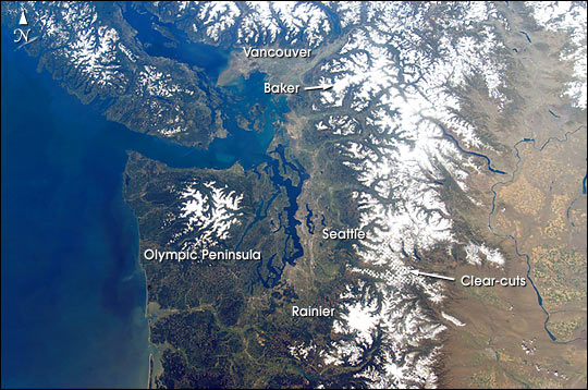 |
| This cloudless view of northwestern Washington and southeastern British Columbia is a study in varied land-use patterns: the forested Olympic Peninsula and Cascade Range contrast with the wheatlands of the drier east side of the mountains. The checkerboard pattern of clearcut forest is accented by snow in the range east of Seattle. Major cities and seaports of the Pacific Northwest--Seattle, Tacoma and Vancouver--take advantage of the deep, sheltered channels. The natural beauty and safe harbors of the region are products of tectonic processes acting on the western margin of North America. Mt. Rainier and Mt. Baker are just two in a line of recently active volcanoes extending from the Coast Mountains of British Columbia to Mt. Shasta in northern California. Strong earthquakes are also frequent, as exemplified by the Nisqually quake (magnitude Mw 6.8) of February 28, 2001, which rocked Tacoma, Seattle and the surrounding area. Information Source: Nisqually Earthquake Information Clearinghouse: //maximus.ce.washington.edu/~nisqually/ |
| Images: | All Available Images Low-Resolution 75k |
|
| Mission: | ISS004 |
|
| Roll - Frame: | E - 10921 |
|
| Geographical Name: | USA-WASHINGTON |
|
| Features: | PUGET SOUND, OLYMPIC PENINSULA |
|
| Center Lat x Lon: | 48.5N x 122.5W |
|
| Film Exposure: | N=Normal exposure, U=Under exposed, O=Over exposed, F=out of Focus |
|
| Percentage of Cloud Cover-CLDP: | 10 |
|
| Camera:: | E4 |
|
| Camera Tilt: | 40 | LO=Low Oblique, HO=High Oblique, NV=Near Vertical |
| Camera Focal Length: | 24 |
|
| Nadir to Photo Center Direction: | NW | The direction from the nadir to the center point, N=North, S=South, E=East, W=West |
| Stereo?: | Y=Yes there is an adjacent picture of the same area, N=No there isn't |
|
| Orbit Number: | 3653 |
|
| Date: | 20020429 | YYYYMMDD |
| Time: | 213252 | GMT HHMMSS |
| Nadir Lat: | 46.3N |
Latitude of suborbital point of spacecraft |
| Nadir Lon: | 120.6W |
Longitude of suborbital point of spacecraft |
| Sun Azimuth: | 219 | Clockwise angle in degrees from north to the sun measured at the nadir point |
| Space Craft Altitude: | 209 | nautical miles |
| Sun Elevation: | 53 | Angle in degrees between the horizon and the sun, measured at the nadir point |
| Land Views: | COAST, FOREST, PENINSULA, RANGE |
|
| Water Views: | |
|
| Atmosphere Views: | |
|
| Man Made Views: | |
|
| City Views: | SEATTLE, VANCOUVER |
|
Photo is not associated with any sequences | ||
| NASA Home Page |
JSC Home Page |
JSC Digital Image Collection |
Earth Science & Remote Sensing |
|
This service is provided by the International Space Station program and the JSC Earth Science & Remote Sensing Unit, ARES Division, Exploration Integration Science Directorate.

|