
Geographic Region: USA-CALIFORNIA
Feature: SAN FRANCISCO BAY AREA
|
Geographic Region: USA-CALIFORNIA Feature: SAN FRANCISCO BAY AREA |
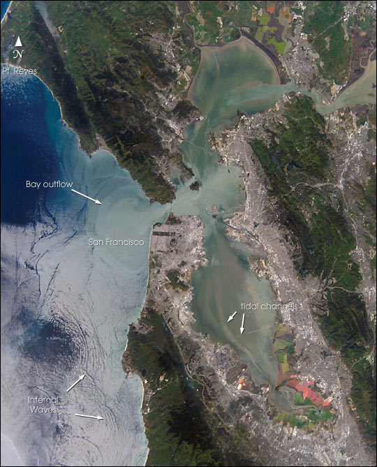 |
| Astronauts aboard the International Space Station (ISS) recently photographed the San Francisco Bay area. The gray urban footprint of San Francisco, Oakland, San Jose, and their surrounding suburbs contrast strongly with the green hillsides. Of particular note are the Pacific Ocean water patterns that are highlighted in the sun glint. Sets of internal waves traveling east impinge on the coastline south of San Francisco. At the same time, fresher bay water flows out from the bay beneath the Golden Gate Bridge, creating a large plume traveling westward. Tidal current channels suggest the tidal flow deep in the bay. Because the ISS orbits are not synchronous with the sun, astronauts view the Earth with variable solar illumination angles. This allows them to document phenomena such as the sun reflecting differentially off surface waters in a way that outlines complicated water structures. |
| Images: | All Available Images Low-Resolution 100k |
|
| Mission: | ISS004 |
|
| Roll - Frame: | E - 10288 |
|
| Geographical Name: | USA-CALIFORNIA |
|
| Features: | SAN FRANCISCO BAY AREA |
|
| Center Lat x Lon: | 37.5N x 122.5W |
|
| Film Exposure: | N=Normal exposure, U=Under exposed, O=Over exposed, F=out of Focus |
|
| Percentage of Cloud Cover-CLDP: | 10 |
|
| Camera:: | E4 |
|
| Camera Tilt: | 35 | LO=Low Oblique, HO=High Oblique, NV=Near Vertical |
| Camera Focal Length: | 105 |
|
| Nadir to Photo Center Direction: | E | The direction from the nadir to the center point, N=North, S=South, E=East, W=West |
| Stereo?: | Y=Yes there is an adjacent picture of the same area, N=No there isn't |
|
| Orbit Number: | 3527 |
|
| Date: | 20020421 | YYYYMMDD |
| Time: | 191952 | GMT HHMMSS |
| Nadir Lat: | 38.5N |
Latitude of suborbital point of spacecraft |
| Nadir Lon: | 124.7W |
Longitude of suborbital point of spacecraft |
| Sun Azimuth: | 150 | Clockwise angle in degrees from north to the sun measured at the nadir point |
| Space Craft Altitude: | 209 | nautical miles |
| Sun Elevation: | 61 | Angle in degrees between the horizon and the sun, measured at the nadir point |
| Land Views: | |
|
| Water Views: | BAY, OCEAN |
|
| Atmosphere Views: | |
|
| Man Made Views: | BRIDGE |
|
| City Views: | OAKLAND, SAN FRANCISCO, SAN JOSE |
|
Photo is not associated with any sequences | ||
| NASA Home Page |
JSC Home Page |
JSC Digital Image Collection |
Earth Science & Remote Sensing |
|
This service is provided by the International Space Station program and the JSC Earth Science & Remote Sensing Unit, ARES Division, Exploration Integration Science Directorate.

|