Geographic Region: SICILY
Feature: MOUNT ETNA, SMOKE PLUME
|
Geographic Region: SICILY Feature: MOUNT ETNA, SMOKE PLUME |
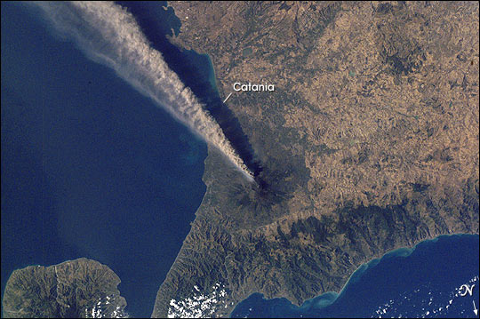 |
| When this southward-looking photograph was taken by the Expedition 2 crew aboard the International Space Station, the city of Catania (in shadow, ~25 km SSE of the volcano) was covered by a layer of ash and Fontanarossa International Airport was closed. On that day an ash cloud was reported to have reached a maximum height of ~5.2 km. Plumes from two sources are visible here--a dense, darker mass from one of the three summit craters and a lighter, lower one. The record of historical volcanism of Mt. Etna is one of the longest in the world, dating back to 1500 BC. Two styles of activity are typical: explosive eruptions, sometimes with minor lava flows, from the summit craters and flank eruptions from fissures. |
| Images: | All Available Images Low-Resolution 61k |
|
| Mission: | ISS002 |
|
| Roll - Frame: | E - 8683 |
|
| Geographical Name: | SICILY |
|
| Features: | MOUNT ETNA, SMOKE PLUME |
|
| Center Lat x Lon: | 38.0N x 15.0E |
|
| Film Exposure: | N=Normal exposure, U=Under exposed, O=Over exposed, F=out of Focus |
|
| Percentage of Cloud Cover-CLDP: | 10 |
|
| Camera:: | E2 |
|
| Camera Tilt: | LO=Low Oblique, HO=High Oblique, NV=Near Vertical |
|
| Camera Focal Length: | 70 |
|
| Nadir to Photo Center Direction: | The direction from the nadir to the center point, N=North, S=South, E=East, W=West |
|
| Stereo?: | Y=Yes there is an adjacent picture of the same area, N=No there isn't |
|
| Orbit Number: | |
|
| Date: | 2001____ | YYYYMMDD |
| Time: | GMT HHMMSS |
|
| Nadir Lat: | N |
Latitude of suborbital point of spacecraft |
| Nadir Lon: | E |
Longitude of suborbital point of spacecraft |
| Sun Azimuth: | Clockwise angle in degrees from north to the sun measured at the nadir point |
|
| Space Craft Altitude: | nautical miles |
|
| Sun Elevation: | Angle in degrees between the horizon and the sun, measured at the nadir point |
|
| Land Views: | VOLCANO |
|
| Water Views: | |
|
| Atmosphere Views: | |
|
| Man Made Views: | AIRPORT |
|
| City Views: | CATANIA |
|
Photo is not associated with any sequences | ||
| NASA Home Page |
JSC Home Page |
JSC Digital Image Collection |
Earth Science & Remote Sensing |
|
This service is provided by the International Space Station program and the JSC Earth Science & Remote Sensing Unit, ARES Division, Exploration Integration Science Directorate.

|