Geographic Region: ARGENTINA
Feature: SAN LORENZO PEAK, LAKES
|
Geographic Region: ARGENTINA Feature: SAN LORENZO PEAK, LAKES |
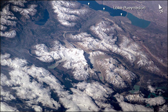 |
| Erosion by Ice and Water in the Southern Andes This scene on the remote, rugged Argentine/Chilean border in the far southern Andes Mountains offers numerous, dramatic examples of both erosional processes and features of ice and water. The sharp, glaciated crest of the Cerro San Lorenzo (center) exceeds 12,000 feet and casts a long shadow southeastward. Glaciers on its western flank flow into the valley. Lago Pueyrredon, and the other lakes visible here, have been excavated by geologically recent episodes of glacier erosion, when glaciers extended all the way onto the lowland plains (top right). Since the last melting of the glaciers (~15,000 years ago) three distinct "fan-deltas" (semicircular features-arrows) have formed where rivers flow into the lake. Counterclockwise currents in the lake-driven by strong winds from the west-have generated thin sand spits from each fan-delta. The largest spit (attached to the largest fan-delta, see right arrow) has isolated an approximately 10-kilometer long segment of the south end of the lake. This river, which has constructed the large fan, presently discharges turbid water to this isolated basin, giving it a lighter color than the rest of the lake. This Electronic Still Camera photo was taken from the International Space Station, in December 2000 (late spring) when most of the previous winter's snow had melted below an altitude of 6,000 feet. Little evidence of man's presence can be found in this rough, desolate region. Glacial data collected over the past 50 years indicate that small ice bodies are disappearing at accelerated rates. (EOS, vol 81, no. 24, June 13, 2000) Predictions are that large fluctuations in land ice, with significant implications to society, are possible in the coming decades and centuries due to natural and anthropogenic climate change. Before glacial data can be used to address critical problems pertaining to the world's economic and environmental health, more detailed information about such glaciers is needed. Images like this from the International Space Station can be added to those taken from satellites (Landsat-7, instruments on the Terra satellite launched in 1999) to build data sets of glaciers in remote areas around the world. |
| Images: | All Available Images Low-Resolution 60k |
|
| Mission: | ISS001 |
|
| Roll - Frame: | E - 5113 |
|
| Geographical Name: | ARGENTINA |
|
| Features: | SAN LORENZO PEAK, LAKES |
|
| Center Lat x Lon: | 47.5S x 72W |
|
| Film Exposure: | N=Normal exposure, U=Under exposed, O=Over exposed, F=out of Focus |
|
| Percentage of Cloud Cover-CLDP: | 25 |
|
| Camera:: | E2 |
|
| Camera Tilt: | LO=Low Oblique, HO=High Oblique, NV=Near Vertical |
|
| Camera Focal Length: | 400 |
|
| Nadir to Photo Center Direction: | The direction from the nadir to the center point, N=North, S=South, E=East, W=West |
|
| Stereo?: | Y=Yes there is an adjacent picture of the same area, N=No there isn't |
|
| Orbit Number: | |
|
| Date: | 200012__ | YYYYMMDD |
| Time: | GMT HHMMSS |
|
| Nadir Lat: | N |
Latitude of suborbital point of spacecraft |
| Nadir Lon: | E |
Longitude of suborbital point of spacecraft |
| Sun Azimuth: | Clockwise angle in degrees from north to the sun measured at the nadir point |
|
| Space Craft Altitude: | nautical miles |
|
| Sun Elevation: | Angle in degrees between the horizon and the sun, measured at the nadir point |
|
| Land Views: | BASIN, EROSION, GLACIER, VALLEY |
|
| Water Views: | DELTA, ICE, LAKE, RIVER |
|
| Atmosphere Views: | |
|
| Man Made Views: | |
|
| City Views: | |
|
Photo is not associated with any sequences | ||
| NASA Home Page |
JSC Home Page |
JSC Digital Image Collection |
Earth Science & Remote Sensing |
|
This service is provided by the International Space Station program and the JSC Earth Science & Remote Sensing Unit, ARES Division, Exploration Integration Science Directorate.

|