Geographic Region: EGYPT
Feature: ALEXANDRIA
|
Geographic Region: EGYPT Feature: ALEXANDRIA |
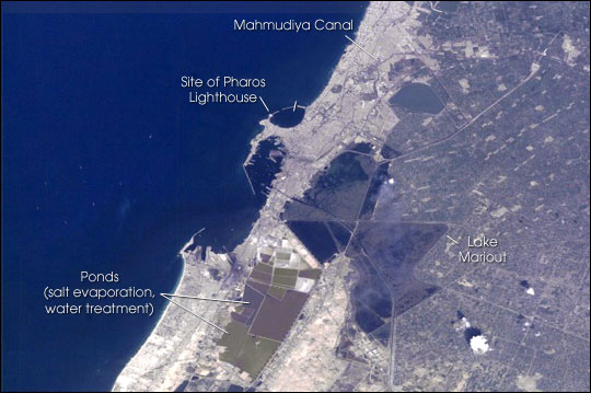 |
| Alexandria (Al Iskandariya), Egypt Alexandria (Al Iskandariya) occupies a T-shaped peninsula and strip of land separating the Mediterranean from Lake Mariout. Originally the town was built upon a mole (stone breakwater) called Heptastadium, which joined the island of Pharos to the mainland. Since then sedimentary deposits have added considerably to the width of the mole. Since 1905, when the city's 370 thousand inhabitants lived in an area of about 4 km2 between the two harbours, the city (population 4 million) has grown beyond its medieval walls and now occupies an area of about 300 km2. The Mahmudiya Canal, connecting Alexandria with the Nile, runs to the south of the city and, by a series of locks, enters the harbour of the principal port of Egypt (note ships). The reddish and ochre polygons west of Lake Mariout are salt-evaporation, chemical-storage, and water-treatment ponds within the coastal lagoon. Some variation in water color seen in Mex Bay and the Western Harbour is due to municipal and industrial waste water entering the Mediterranean. The total cumulative volume of waste water disposed of into the sea from all point sources along this stretch of coast is about equal to the Nile outflow from the Rosetta outlet: roughly 9 million m3/day; that is, 3.33 km3/yr. Two thirds of the city waste water is released into Lake Mariout and subsequently pumped into Mex Bay, along with agricultural runoff from the northwestern delta. A few hundred meters from the foundered Pharos lighthouse, 200,000 m3 of waste water enter the sea each day at Qait Bey. The city government is building water treatment facilities and working to mitigate water-quality problems and to protect antiquities. Alexandria was founded in 331 B.C. by Alexander the Great and served as the capital of Egypt for more than 1,000 years. The ruins of Pharos, the first lighthouse and one of the seven wonders of the ancient world, now lie beneath the Mediterranean. In about 295 B.C. Ptolemy I Soter began to construct the Great Library at Alexandria, the premier intellectual resource of the age; it was later destroyed by the caliph Umar in 640 A.D. The new Bibliotheca Alexandrina, being constructed by the Egyptian government in cooperation with UNESCO, is nearing completion and is due to open in spring, 2001. |
| Images: | All Available Images Low-Resolution 48k |
|
| Mission: | ISS001 |
|
| Roll - Frame: | E - 5025 |
|
| Geographical Name: | EGYPT |
|
| Features: | ALEXANDRIA |
|
| Center Lat x Lon: | 31.0N x 30.0E |
|
| Film Exposure: | N=Normal exposure, U=Under exposed, O=Over exposed, F=out of Focus |
|
| Percentage of Cloud Cover-CLDP: | 10 |
|
| Camera:: | E2 |
|
| Camera Tilt: | LO=Low Oblique, HO=High Oblique, NV=Near Vertical |
|
| Camera Focal Length: | 400 |
|
| Nadir to Photo Center Direction: | The direction from the nadir to the center point, N=North, S=South, E=East, W=West |
|
| Stereo?: | Y=Yes there is an adjacent picture of the same area, N=No there isn't |
|
| Orbit Number: | |
|
| Date: | 200012__ | YYYYMMDD |
| Time: | GMT HHMMSS |
|
| Nadir Lat: | N |
Latitude of suborbital point of spacecraft |
| Nadir Lon: | E |
Longitude of suborbital point of spacecraft |
| Sun Azimuth: | Clockwise angle in degrees from north to the sun measured at the nadir point |
|
| Space Craft Altitude: | nautical miles |
|
| Sun Elevation: | Angle in degrees between the horizon and the sun, measured at the nadir point |
|
| Land Views: | COAST, ISLAND, PENINSULA |
|
| Water Views: | BAY, CANAL, DELTA, LAGOON, LAKE, SEA |
|
| Atmosphere Views: | |
|
| Man Made Views: | PORT |
|
| City Views: | ALEXANDRIA |
|
Photo is not associated with any sequences | ||
| NASA Home Page |
JSC Home Page |
JSC Digital Image Collection |
Earth Science & Remote Sensing |
|
This service is provided by the International Space Station program and the JSC Earth Science & Remote Sensing Unit, ARES Division, Exploration Integration Science Directorate.

|