Return to Earth From Space Home
Earth from Space logo Image Information Earth from Space logo

Display a Screen Layout for Printing

IMAGE: gray corner       IMAGE: gray corner
  Image: Geographic Location Direction Photo #: STS057-75-46 Date: Jun. 1993
Geographic Region: PERU
Feature: LAKE TITICACA, VOLS., MTS.

Ordering information for space photography
 
IMAGE: gray corner     IMAGE: gray corner

Image: gray corner     Image: gray corner
  View Low-Resolution Image  
  STS057-075-046 Lake Titicaca, Bolivia and Peru June 1993
Lake Titicaca, the largest freshwater lake in South America, can be seen in this low-oblique, southeast-looking photograph. Lake Titicaca is located in a depression in the Altiplano (high plains) between the eastern (greenish, forest-covered mountains east of the lake, partially obscured by clouds) and the western (brownish area west of the lake with numerous volcanic peaks) range of the Andes Mountains. Lake Titicaca covers an area of 3200 square miles (8300 square kilometers), is nearly 120 miles (190 kilometers) long, and has an average width of 45 miles (72 kilometers). Fed by many mountain streams that border the Altiplano, the lake is drained only by the Desaguadero River, which flows south into Lake Poopó (not visible in the photograph). Water levels can vary as much as 16 feet (5 meters) from season to season and year to year. Much of the lake water is lost through evaporation caused by intense sunshine and strong winds. Since the late 1980s, drought has plagued this region of the Altiplano, causing water levels in the lake to drop below normal. The whitish areas scattered around the lakeshore are newly exposed lake bottom areas. A small tail-like portion at the northern end of the lake (visible in the photograph) has been cut off from the main body of the lake because the water level has receded. Drastic drops in water level in the lake could eventually affect the moderating climate of this high-altitude lake 12 500 feet (3800 meters) above sea level, which could lead to reduced agricultural crop yields. The agricultural crops of wheat and maize help sustain many Indians that live along Lake Titicaca's shores. (Refer to STS-51G-037-0028 for an earlier photograph and description of Lake Titicaca.)
 
Image: gray corner     Image: gray corner

Images: All Available Images Low-Resolution 178k
Mission: STS057  
Roll - Frame: 75 - 46
Geographical Name: PERU  
Features: LAKE TITICACA, VOLS., MTS.  
Center Lat x Lon: 16S x 69.5W
Film Exposure: N   N=Normal exposure, U=Under exposed, O=Over exposed, F=out of Focus
Percentage of Cloud Cover-CLDP: 5
 
Camera: HB
 
Camera Tilt: 44   LO=Low Oblique, HO=High Oblique, NV=Near Vertical
Camera Focal Length: 100  
 
Nadir to Photo Center Direction: SE   The direction from the nadir to the center point, N=North, S=South, E=East, W=West
Stereo?: N   Y=Yes there is an adjacent picture of the same area, N=No there isn't
Orbit Number: 21  
 
Date: 19930622   YYYYMMDD
Time: 204837   GMT HHMMSS
Nadir Lat: 13.5S  
Latitude of suborbital point of spacecraft
Nadir Lon: 72.6W  
Longitude of suborbital point of spacecraft
Sun Azimuth: 302   Clockwise angle in degrees from north to the sun measured at the nadir point
Space Craft Altitude: 251   nautical miles
Sun Elevation: 22   Angle in degrees between the horizon and the sun, measured at the nadir point
Land Views: MOUNTAIN, VOLCANO, PLAIN, BASIN  
Water Views: LAKE, RIVER  
Atmosphere Views:  
Man Made Views:  
City Views:  
Associated Photos in Sequence:

IMAGEPhoto #: STS057-99-65
Description: PERU/BOLIVIA-1993; L. TITICACA, L. POOPO REGION-SYNOPTIC VIEW
Sequence ID: 5A

IMAGEPhoto #: STS51G-37-28
Description: LAKE TITICACA-1985--DETAILED VIEW; LAKE LEVEL
Sequence ID: 5B

IMAGE
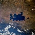
Photo #: STS057-75-46 ** Currently displayed photo **
Description: LAKE TITICACA-1993--DETAILED VIEW; LAKE LEVEL CHANGE
Sequence ID: 5C


NASA
Home Page
JSC
Home Page
JSC Digital
Image Collection
Earth Science &
Remote Sensing

NASA meatball logo
This service is provided by the International Space Station program and the JSC Earth Science & Remote Sensing Unit, ARES Division, Exploration Integration Science Directorate.
ESRS logo