STS51I-44-52
| NASA Photo ID | STS51I-44-52 |
| Focal Length | 100mm |
| Date taken | 1985.09.01 |
| Time taken | 11:57:51 GMT |
Resolutions offered for this image:
3921 x 3975 pixels 631 x 639 pixels 5700 x 5900 pixels 500 x 518 pixels 640 x 480 pixels 1874 x 1938 pixels 411 x 424 pixels
3921 x 3975 pixels 631 x 639 pixels 5700 x 5900 pixels 500 x 518 pixels 640 x 480 pixels 1874 x 1938 pixels 411 x 424 pixels


Cloud masks available for this image:
Spacecraft nadir point: 21.2° N, 80.3° W
Photo center point:
Photo center point by machine learning:
Photo center point:
Photo center point by machine learning:
Nadir to Photo Center:
Spacecraft Altitude: 234 nautical miles (433km)
Country or Geographic Name: | GULF OF MEXICO |
Features: | HURRICANE ELENA |
| Features Found Using Machine Learning: | |
Cloud Cover Percentage: | 90 (76-100)% |
Sun Elevation Angle: | 11° |
Sun Azimuth: | 85° |
Camera: | Hasselblad |
Focal Length: | 100mm |
Camera Tilt: | High Oblique |
Format: | 5017: Kodak, natural color positive, Ektachrome, X Professional, ASA 64, standard base |
Film Exposure: | Normal |
| Additional Information | |
| Width | Height | Annotated | Cropped | Purpose | Links |
|---|---|---|---|---|---|
| 3921 pixels | 3975 pixels | No | No | Earth From Space collection | Download Image |
| 631 pixels | 639 pixels | No | No | Earth From Space collection | Download Image |
| 5700 pixels | 5900 pixels | No | No | Download Image | |
| 500 pixels | 518 pixels | No | No | Download Image | |
| 640 pixels | 480 pixels | No | No | Download Image | |
| 1874 pixels | 1938 pixels | No | No | Download Image | |
| 411 pixels | 424 pixels | Download Image |
Download Packaged File
Download a Google Earth KML for this Image
View photo footprint information
Download a GeoTIFF for this photo
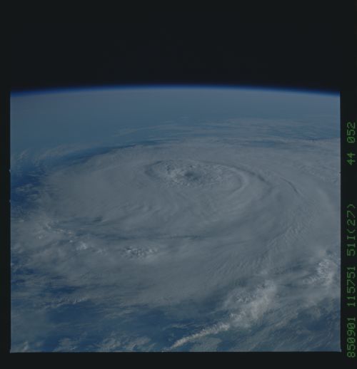
Image Caption: STS51I-44-0052 Hurricane Elena, Gulf of Mexico September 1985
Hurricane Elena, with wind speeds in excess of 110 miles per hour (177 kilometers per hour), was photographed in the Gulf of Mexico on September 1, 1985. Almost the entire storm can be seen in this high-oblique photograph. For instance, a number of thunderstorms with their overshooting tops, the spiral bands of numerous thunderstorms leading to the eye of the hurricane, and numerous cloud gravity waves within the spiral bands can be seen. Some portions of the eye wall, where the most destructive winds of the storm occur, are also visible. This storm eventually made landfall near Gulfport, Mississippi.
Hurricane Elana in the Gulf of Mexico, exact location unknown. The presence of a tight, well formed, gyre and elevated cloud berm bordering the eye, are indicators of a very powerful and dangerous hurricane with very high internal cyclonic wind speeds.
