ISS049-E-1028
| NASA Photo ID | ISS049-E-1028 |
| Focal Length | 800mm |
| Date taken | 2016.09.10 |
| Time taken | 17:28:49 GMT |
1000 x 666 pixels 540 x 360 pixels 4928 x 3280 pixels 720 x 480 pixels 720 x 480 pixels 4928 x 3280 pixels 640 x 426 pixels
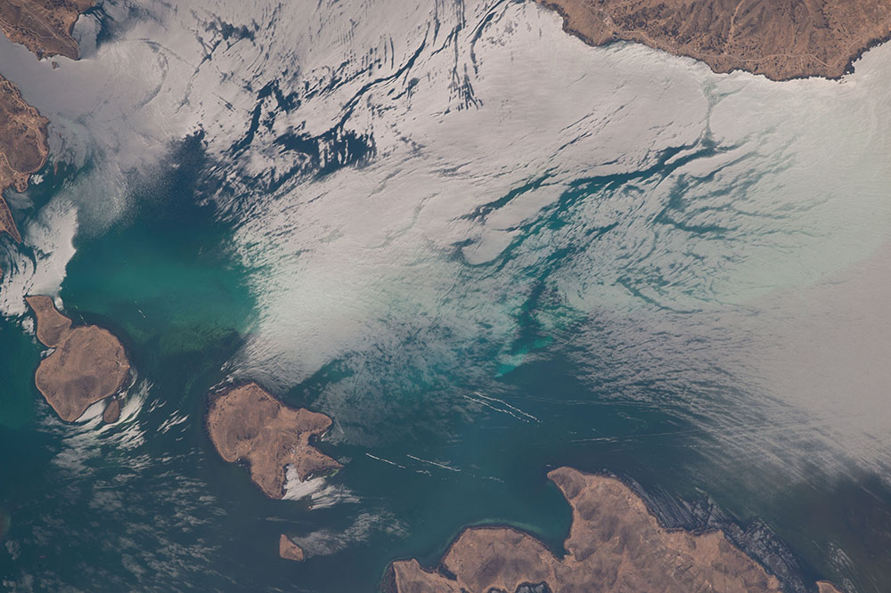
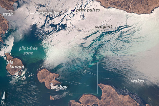

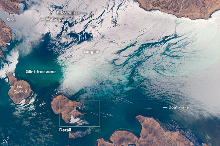

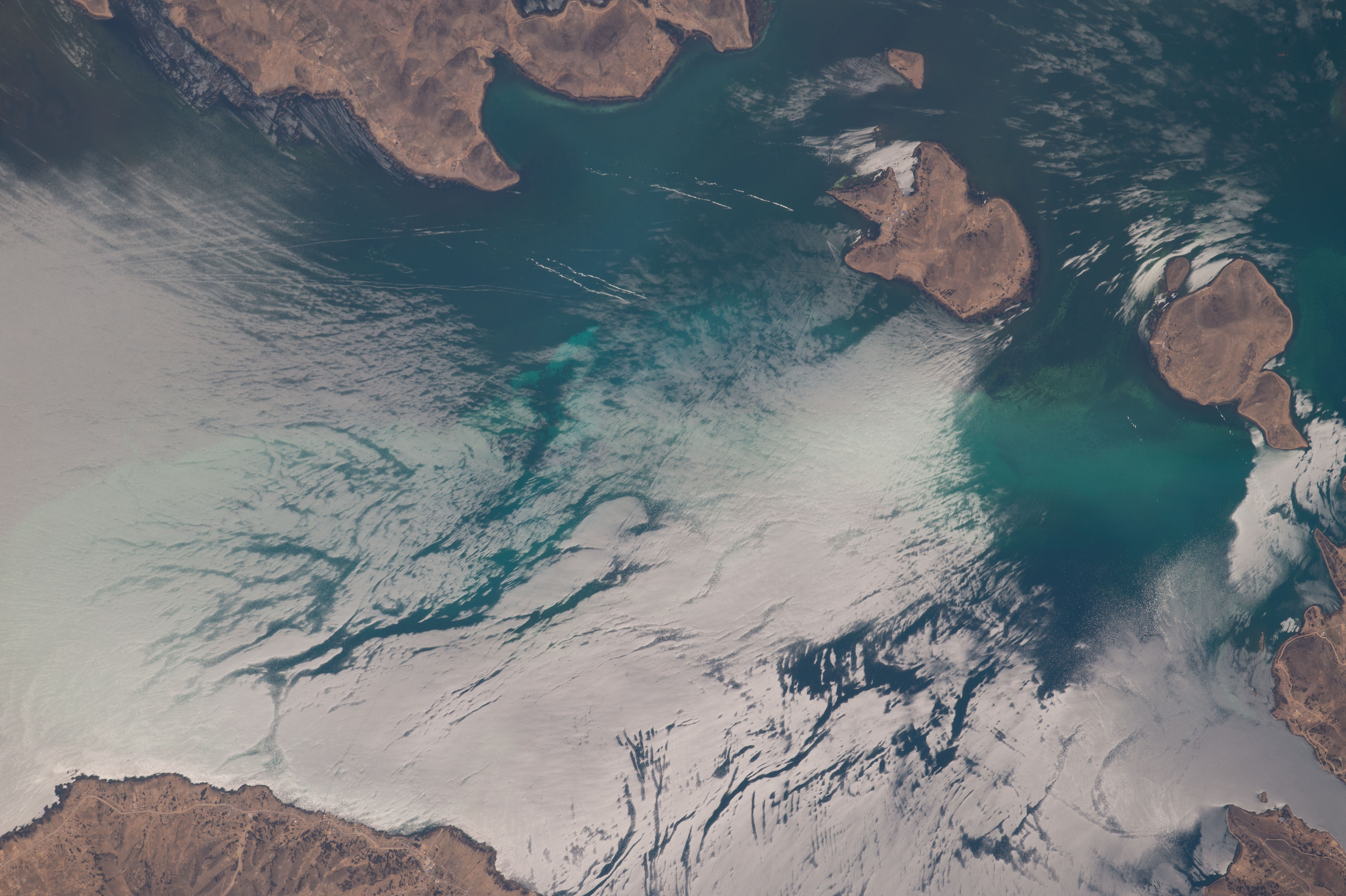

Photo center point: 16.3° S, 68.7° W
Photo center point by machine learning: 16.27° S, 68.73° W

Country or Geographic Name: | BOLIVIA |
Features: | L. TITICACA, GLINT, BOAT WAKES |
| Features Found Using Machine Learning: | |
Cloud Cover Percentage: | 10 (1-10)% |
Sun Elevation Angle: | 61° |
Sun Azimuth: | 322° |
Camera: | Nikon D4 Electronic Still Camera |
Focal Length: | 800mm |
Camera Tilt: | 46 degrees |
Format: | 4928E: 4928 x 3280 pixel CMOS sensor, 36.0mm x 23.9mm, total pixels: 16.6 million, Nikon FX format |
Film Exposure: | |
| Additional Information | |
| Width | Height | Annotated | Cropped | Purpose | Links |
|---|---|---|---|---|---|
| 1000 pixels | 666 pixels | No | No | Earth From Space collection | Download Image |
| 540 pixels | 360 pixels | Yes | No | Earth From Space collection | Download Image |
| 4928 pixels | 3280 pixels | No | No | NASA's Earth Observatory web site | Download Image |
| 720 pixels | 480 pixels | Yes | No | NASA's Earth Observatory web site | Download Image |
| 720 pixels | 480 pixels | Yes | Yes | NASA's Earth Observatory web site | Download Image |
| 4928 pixels | 3280 pixels | No | No | Download Image | |
| 640 pixels | 426 pixels | No | No | Download Image |
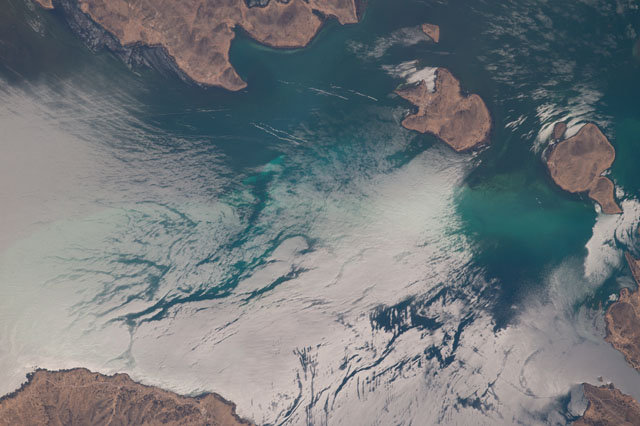
An astronaut aboard the International Space Station used a long lens to capture the fleeting features of the sun's reflection point around islands in Lake Titicaca in the high plateau of the Andes. Lake Titicaca is the largest lake in South America, and lies partly in Peru, partly in Bolivia. Astronauts see numerous complex "sunglint" patterns like these as they look down on Earth.
Here dramatic reflection-point patterns are strongly affected by the wind because wind-ruffled water and smooth water reflect sunlight differently. Strong westerly winds that blow most months of the year disturb the water surface, enhancing bright reflection over most of the top half of the image where the lake is exposed to the wind. Wind is also channeled between steep-sided islands making for strong reflections on both sides of Isla Suriqui (image left margin). But in protected zones--as in the big area downwind of isla Suriqui (northeast of Isla Suriqui) there is no brilliant reflection to blot out color in lake water.
The "sunglint" pattern tells other stories. The curved line at image top left seems to show a pulse of water entering this part of the lake through a narrow strait. The pattern of parallel lines at image top center may represent a "packet" of earlier pulses, features often seen by astronauts in the seas of the world.
At image lower right the straight lines of many boat wakes cut across curved wind-streak lines--none of which would be visible from space outside the glint point (at image lower right). The area of detailed (inset) shows a cluster of V-shaped boat wakes of traffic going to and from the small port on the island lower center. At 3812 meters (12,500 feet) above sea level, Lake Titicaca is one of the highest commercially navigable lakes in the world.
