ISS047-E-111699
| NASA Photo ID | ISS047-E-111699 |
| Focal Length | 1150mm |
| Date taken | 2016.05.09 |
| Time taken | 09:46:59 GMT |
1000 x 666 pixels 540 x 360 pixels 4928 x 3280 pixels 720 x 480 pixels 4928 x 3280 pixels 640 x 426 pixels

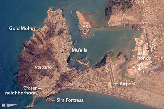

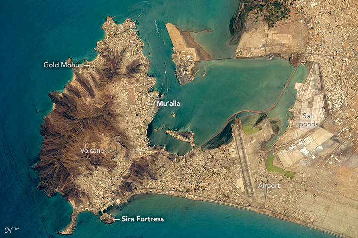


Photo center point: 12.8° N, 45.0° E
Photo center point by machine learning:
Camera: | Nikon D4 Electronic Still Camera |
Focal Length: | 1150mm |
Camera Tilt: | 21 degrees |
Format: | 4928E: 4928 x 3280 pixel CMOS sensor, 36.0mm x 23.9mm, total pixels: 16.6 million, Nikon FX format |
Film Exposure: | |
| Additional Information | |
| Width | Height | Annotated | Cropped | Purpose | Links |
|---|---|---|---|---|---|
| 1000 pixels | 666 pixels | No | No | Earth From Space collection | Download Image |
| 540 pixels | 360 pixels | Yes | No | Earth From Space collection | Download Image |
| 4928 pixels | 3280 pixels | No | No | NASA's Earth Observatory web site | Download Image |
| 720 pixels | 480 pixels | Yes | No | NASA's Earth Observatory web site | Download Image |
| 4928 pixels | 3280 pixels | No | No | Download Image | |
| 640 pixels | 426 pixels | No | No | Download Image |
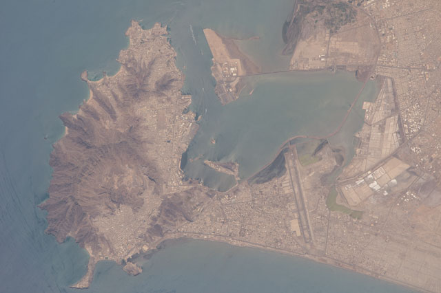
Orbiting almost directly over the port of Aden, a crew member aboard the International Space Station (ISS) took this detailed shot of a rugged, extinct volcano (at image left), and the flat sand spit next to it (at image center and right) and the big bay protected by the volcano--that now all form the port of Aden. Part of the city is even known as the Crater neighborhood (at image lower left) that looks down onto the docks of the old port (the old port is protected by a small island with an 11th century fortress, the Sira Fortress, which is still used). Swell trains appear on the side of the volcano exposed to the open sea as thin, parallel blue lines (at image lower left). The tourist part of Aden is Gold Mohur (at image top left) which takes advantage of the beaches and surf of this open coastline, all against the dramatic backdrop of the volcano. On the well protected bay side of the volcano lies the much larger harbor of Al Mu'alla (at image center), the economic hub of Aden.
The flat lands of the sand spit allowed numerous salt ponds to be constructed, where sea water can be evaporated in the almost constant sunshine. These bright, angular shapes are the most striking visual features seen from the ISS (at image right), apart from the volcano. Salt production has been a major export from Aden for centuries. The Aden International Airport (the former British Royal Air Force station RAF Khormaksar), Yemen's second biggest airport, also occupies these flat surfaces. The runways are 3.5 km long (2 miles). The city's diplomatic missions and the main campus of Aden University surround the airport.
Aden lies near the southern end of the Red Sea, at a critical point where major sea lanes converge--between Egypt and the Mediterranean Sea, the Persian Gulf and India, and the long shoreline of East Africa. To protect sea lanes to India and the Far East, Great Britain occupied Aden and the surrounding southern parts of the Arabian Peninsula inland from 1839 to 1967. For the same reason the small enclave of Djibouti on the opposite coast in Africa at the southern end of the Red Sea.
