ISS046-E-693
| NASA Photo ID | ISS046-E-693 |
| Focal Length | 1150mm |
| Date taken | 2015.12.13 |
| Time taken | 11:06:18 GMT |
1000 x 666 pixels 540 x 360 pixels 4928 x 3280 pixels 720 x 480 pixels 4928 x 3280 pixels 640 x 426 pixels
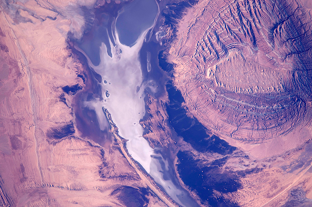
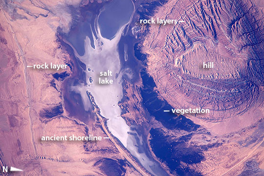

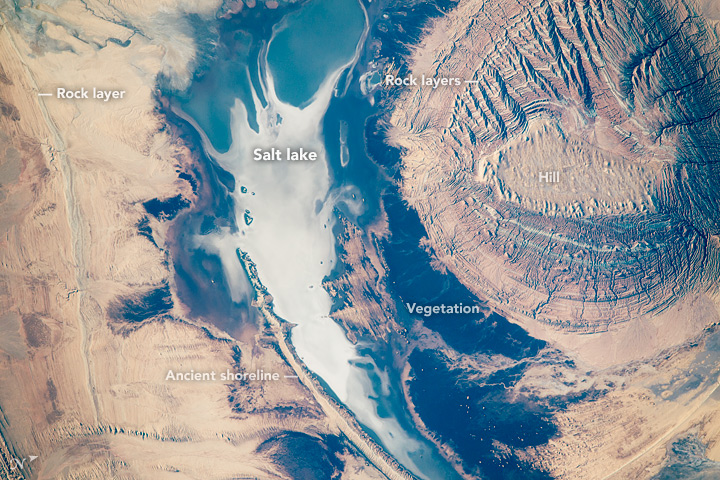


Photo center point: 34.9° N, 54.0° E
Photo center point by machine learning:
Country or Geographic Name: | IRAN |
Features: | KAVIR DESERT, SALT LAKE, SHORELINE, MESA |
| Features Found Using Machine Learning: | |
Cloud Cover Percentage: | 10 (1-10)% |
Sun Elevation Angle: | 20° |
Sun Azimuth: | 221° |
Camera: | Nikon D4 Electronic Still Camera |
Focal Length: | 1150mm |
Camera Tilt: | 04 degrees |
Format: | 4928E: 4928 x 3280 pixel CMOS sensor, 36.0mm x 23.9mm, total pixels: 16.6 million, Nikon FX format |
Film Exposure: | |
| Additional Information | |
| Width | Height | Annotated | Cropped | Purpose | Links |
|---|---|---|---|---|---|
| 1000 pixels | 666 pixels | No | No | Earth From Space collection | Download Image |
| 540 pixels | 360 pixels | Yes | No | Earth From Space collection | Download Image |
| 4928 pixels | 3280 pixels | No | No | NASA's Earth Observatory web site | Download Image |
| 720 pixels | 480 pixels | Yes | No | NASA's Earth Observatory web site | Download Image |
| 4928 pixels | 3280 pixels | No | No | Download Image | |
| 640 pixels | 426 pixels | No | No | Download Image |
Part of the astronaut experience is seeing very many landscape and geology patterns, especially in deserts where vegetation is thin on the ground. A crew member aboard the International Space Station took this image of a circular hill in central Iran (image right). Even from 400 km up in space, this long-lens image shows details of the small (3.25 km long) flat hilltop. Numerous, multi-colored lines on the sides of the hill show that the hill is made of many thin layers of sedimentary rock. The neighboring dry lake has a white salt-covered surface. By contrast, the darkest areas are shrubby desert vegetation on the lowest slopes of the hill, the only zone where enough water concentrates to allow vegetation to grow.
The astronaut might even be able to tell the difference between the long curved lines on the left of the image. One is an ancient shoreline formed when the lake contained permanent water--with waves strong enough to shape sediments into the form of a smooth beach. Another curved, slightly irregular line is a harder rock layer sticking out of the desert floor.
