ISS046-E-19670

| NASA Photo ID | ISS046-E-19670 |
| Focal Length | 400mm |
| Date taken | 2016.01.23 |
| Time taken | 13:25:22 GMT |
1000 x 666 pixels 540 x 360 pixels 4928 x 3280 pixels 720 x 480 pixels 4928 x 3280 pixels 640 x 426 pixels


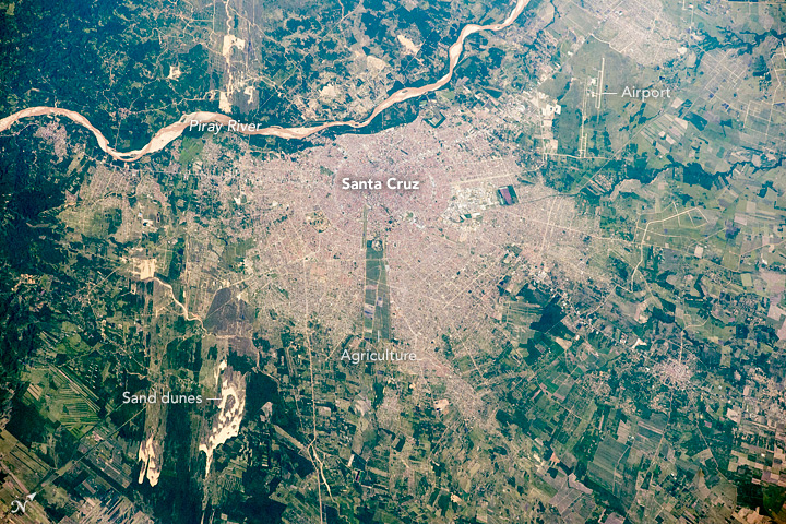
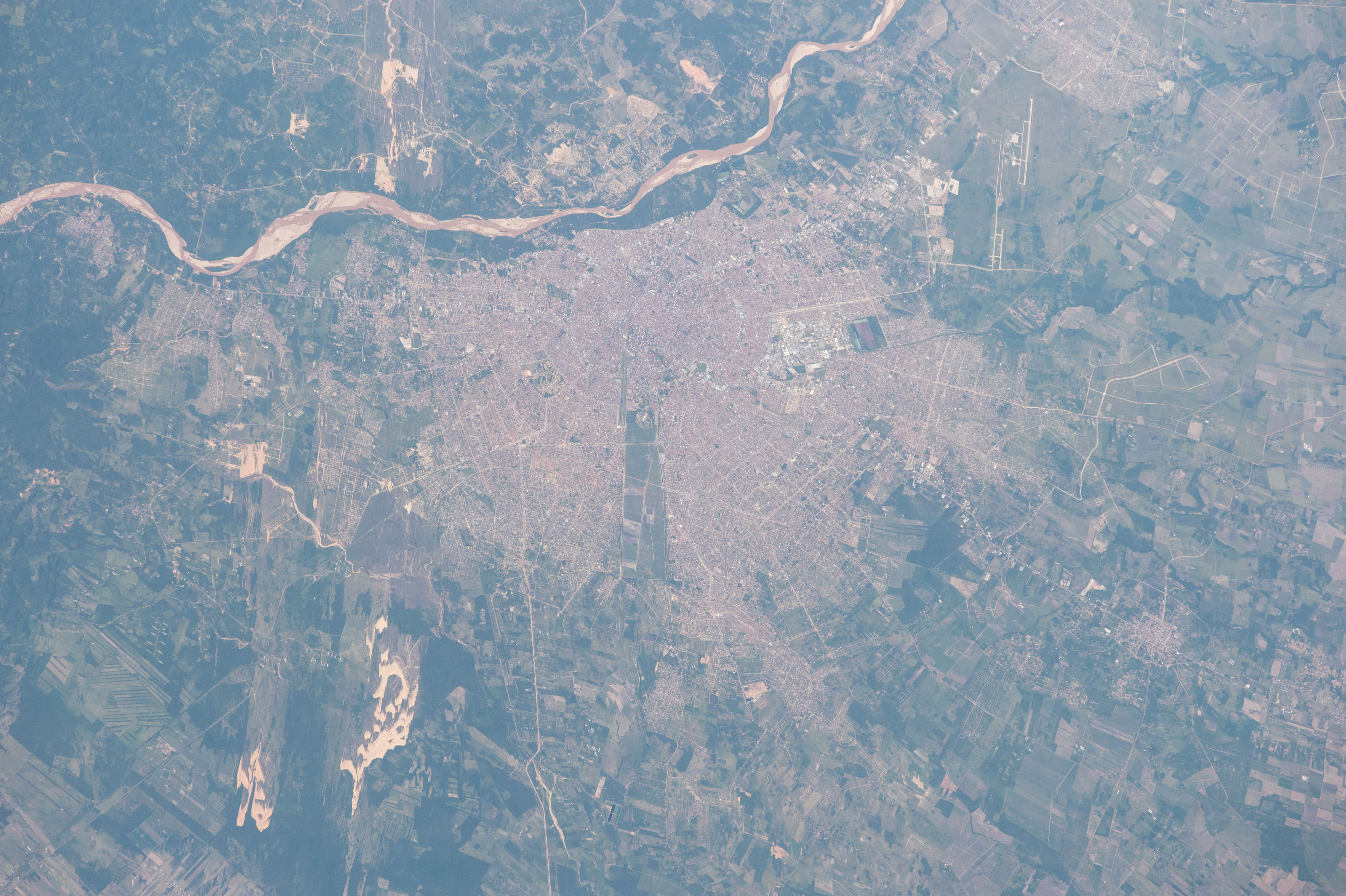


Photo center point: 17.8° S, 63.2° W
Photo center point by machine learning: 17.82° S, 63.15° W

Country or Geographic Name: | BOLIVIA |
Features: | SANTA CRUZ, PIRAY R., AGR. |
| Features Found Using Machine Learning: | |
Cloud Cover Percentage: | 10 (1-10)% |
Sun Elevation Angle: | 49° |
Sun Azimuth: | 97° |
Camera: | Nikon D4 Electronic Still Camera |
Focal Length: | 400mm |
Camera Tilt: | 35 degrees |
Format: | 4928E: 4928 x 3280 pixel CMOS sensor, 36.0mm x 23.9mm, total pixels: 16.6 million, Nikon FX format |
Film Exposure: | |
| Additional Information | |
| Width | Height | Annotated | Cropped | Purpose | Links |
|---|---|---|---|---|---|
| 1000 pixels | 666 pixels | No | No | Earth From Space collection | Download Image |
| 540 pixels | 360 pixels | Yes | No | Earth From Space collection | Download Image |
| 4928 pixels | 3280 pixels | No | No | NASA's Earth Observatory web site | Download Image |
| 720 pixels | 480 pixels | Yes | No | NASA's Earth Observatory web site | Download Image |
| 4928 pixels | 3280 pixels | No | No | Download Image | |
| 640 pixels | 426 pixels | No | No | Download Image |
A crew member aboard the International Space Station (ISS) took this detailed image of the city of Santa Cruz--whose full name is Santa Cruz de la Sierra because it lies just east of the Andes ranges, in the hot, tropical lowlands of east-central Bolivia. Flying at 17,150 miles per hour (27,600 km per hour), astronauts must quickly recognize features on the ground. Approaching this target fast, the prominent feature the astronauts see is the gray-brown line of the Piray River (top part of the image). Then they see the great patch of pink roof tiles of the city, 15-20 km in diameter, with fingers that seem to be expanding into the green agricultural lands that surround the city.
Looking more closely astronauts can see the very classical layout of the city--a series of straight radiating boulevards and concentric ring roads focused on the ancient city center. The Piray River itself and its wide sandy floodplain controls the shape of the modern city, restricting its growth westward. If the river were absent the city would have developed a more circular shape. But the river supplies the city's water, so that the center was established near its bank. A long thin remnant of agricultural fields has been isolated (image center) by the recent growth of the city. Indeed, Santa Cruz and its metropolitan area (2 million people) is one of the fastest-growing cities in the world.
Growth has largely come about because of the expansion of agriculture in the last few decades, especially soybeans, sugarcane, and rice, and because of petroleum and natural gas extraction nearby. City manufacturing (the industrial park northeast of the city center stands out from the tile roofs--image center) produces soybean oil, dairy and meat products, wood products, leather, and alcohol. Oil and sugar refineries are also important. The city's international airport (top right) is the country's busiest.
Earlier courses of the Piray River can be detected in several parts of the image. These relict courses show that the river has flowed northwest (image top left), northeast (green channels near the airport), and east (green channels lower right). By switching its courses, the Piray River has built the vast plain of fertile river sediment where the city and farmland now lie.
Strong winds occasionally blow sand out of the large river beds, making elongated dunefields (image lower left and top left, along the relict river course).
