ISS045-E-55901

| NASA Photo ID | ISS045-E-55901 |
| Focal Length | 1150mm |
| Date taken | 2015.10.10 |
| Time taken | 12:03:30 GMT |
Resolutions offered for this image:
1000 x 782 pixels 540 x 422 pixels 4928 x 3280 pixels 720 x 480 pixels 4928 x 3280 pixels 640 x 426 pixels
1000 x 782 pixels 540 x 422 pixels 4928 x 3280 pixels 720 x 480 pixels 4928 x 3280 pixels 640 x 426 pixels


Spacecraft nadir point: 22.8° N, 48.2° E
Photo center point: 23.5° N, 46.6° E
Photo center point by machine learning:
Photo center point: 23.5° N, 46.6° E
Photo center point by machine learning:
Nadir to Photo Center: West
Spacecraft Altitude: 214 nautical miles (396km)
Country or Geographic Name: | SAUDI ARABIA |
Features: | DESERT CANYONLANDS |
| Features Found Using Machine Learning: | |
Cloud Cover Percentage: | 0 (no clouds present) |
Sun Elevation Angle: | 31° |
Sun Azimuth: | 247° |
Camera: | Nikon D4 Electronic Still Camera |
Focal Length: | 1150mm |
Camera Tilt: | 26 degrees |
Format: | 4928E: 4928 x 3280 pixel CMOS sensor, 36.0mm x 23.9mm, total pixels: 16.6 million, Nikon FX format |
Film Exposure: | |
| Additional Information | |
| Width | Height | Annotated | Cropped | Purpose | Links |
|---|---|---|---|---|---|
| 1000 pixels | 782 pixels | No | No | Earth From Space collection | Download Image |
| 540 pixels | 422 pixels | Yes | Yes | Earth From Space collection | Download Image |
| 4928 pixels | 3280 pixels | No | Yes | NASA's Earth Observatory web site | Download Image |
| 720 pixels | 480 pixels | Yes | No | NASA's Earth Observatory web site | Download Image |
| 4928 pixels | 3280 pixels | No | No | Download Image | |
| 640 pixels | 426 pixels | No | No | Download Image |
Download Packaged File
Download a Google Earth KML for this Image
View photo footprint information
Download a GeoTIFF for this photo
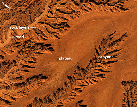
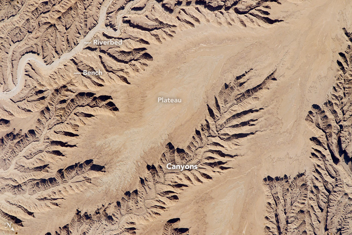
Image Caption: Saudi Arabia Canyonlands
Crews aboard the International Space Station are trained to use low sun angles to add a strong three-dimensional effect to flat landscapes--well illustrated by this image of central Saudi Arabia. The main river (image lower right), located 120 km (75 miles) south of the capital city Riyadh, has eroded its bed down into the rock layers making a small canyon 250 m deep (820 feet). This in turn has led all its tributaries to dig their own canyons--with the resulting elaborate, leaf-like pattern landscape that casts shadows in the late afternoon sun, attracting the astronaut's eye.
This detailed image--the area covered is only 12.5 km (7.7 miles) across--shows a road following the main river. River beds are often the smoothest places in deserts for wheeled vehicles, connecting villages that also occupy river beds and terraces next to rivers, for access to well water. Dark dots in the main river bed are trees that only grow in the river beds where their roots are able to reach subsurface water.
The center of the small plateau surface in the center of the image is a slightly different color from the area surrounding it. This is a lighter-toned layer of sedimentary rock, one of many in the area. Other thin layers make benches within the canyons (image lower left)--in the same style as seen in the Grand Canyon of the USA but on a much smaller scale.
