ISS045-E-148262

| NASA Photo ID | ISS045-E-148262 |
| Focal Length | 400mm |
| Date taken | 2015.11.29 |
| Time taken | 01:53:22 GMT |
1000 x 766 pixels 540 x 414 pixels 2464 x 1640 pixels 720 x 480 pixels 4928 x 3280 pixels 640 x 426 pixels
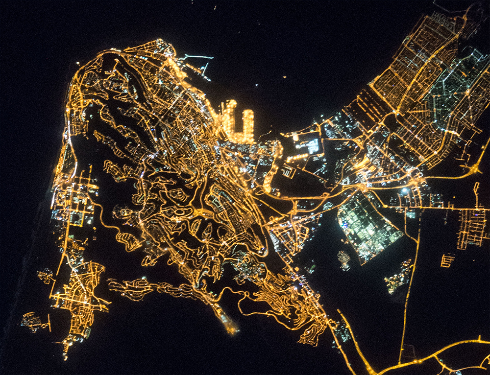


Photo center point: 32.7° N, 35.0° E
Photo center point by machine learning:
Country or Geographic Name: | ISRAEL |
Features: | HAIFA AT NIGHT |
| Features Found Using Machine Learning: | DUBAI |
Cloud Cover Percentage: | 10 (1-10)% |
Sun Elevation Angle: | -18° |
Sun Azimuth: | 106° |
Camera: | Nikon D4 Electronic Still Camera |
Focal Length: | 400mm |
Camera Tilt: | High Oblique |
Format: | 4928E: 4928 x 3280 pixel CMOS sensor, 36.0mm x 23.9mm, total pixels: 16.6 million, Nikon FX format |
Film Exposure: | |
| Additional Information | |
| Width | Height | Annotated | Cropped | Purpose | Links |
|---|---|---|---|---|---|
| 1000 pixels | 766 pixels | No | Yes | Earth From Space collection | Download Image |
| 540 pixels | 414 pixels | Yes | Yes | Earth From Space collection | Download Image |
| 2464 pixels | 1640 pixels | No | Yes | NASA's Earth Observatory web site | Download Image |
| 720 pixels | 480 pixels | Yes | Yes | NASA's Earth Observatory web site | Download Image |
| 4928 pixels | 3280 pixels | No | No | Download Image | |
| 640 pixels | 426 pixels | No | No | Download Image |
Part of the astronaut experience is recognizing--and then photographing--the same place under completely different conditions, in daylight and at night. Astronauts become adept at merging both visions of the planet. The same astronaut probably took both these day and night images (with similar lenses) of the port city of Haifa on Israel's Mediterranean coast. In geography training astronauts are taught to concentrate on the shapes of coastlines because they are first-order visual cue when circling the planet, and often uniquely shaped. The nose of Cape Karmel (image top left) and the bay that protects the Port of Haifa (image upper center) are shapes that can tell crews where they are, especially after they have been in space for a few weeks.
In the daylight image (ISS046-E-1292)the strong visual line of the coast contrasts with the subtle city colors. The steep slope of the north flank of Mount Carmel, facing the port, is marked by a long dark shadow in the midafternoon sun. Shorter shadows indicate several steep-sided canyons that cut into Mount Carmel (image left). Older neighborhoods with linear roads lie on the lower slopes nearer the port. Newer neighborhoods show a pattern of streets that wind along the intricate edges of the canyons. This distinction is best seen in the night image. In a small country where land is scarce, brown farmlands can be seen close to the middle of the city.
The night shot does not show the coastline, unless you know where to look for it. But it does show different city neighborhoods in a way that is difficult to see in the day. The brilliant port lights contrast with the surrounding less bright residential areas. Straight roads of the older residential neighborhoods are easily distinguished from the winding roads that follow the canyon cliffs. The industrial area just east of the port has areas of green and blue lights and a less dense street pattern. Surrounding farmlands are so dark that they can be confused with the sea.
