ISS044-E-610

| NASA Photo ID | ISS044-E-610 |
| Focal Length | 1150mm |
| Date taken | 2015.06.13 |
| Time taken | 20:55:44 GMT |
Resolutions offered for this image:
1000 x 666 pixels 540 x 360 pixels 4928 x 3280 pixels 720 x 480 pixels 4928 x 3280 pixels 640 x 426 pixels
1000 x 666 pixels 540 x 360 pixels 4928 x 3280 pixels 720 x 480 pixels 4928 x 3280 pixels 640 x 426 pixels


Spacecraft nadir point: 42.6° N, 68.8° W
Photo center point: 42.1° N, 70.2° W
Photo center point by machine learning:
Photo center point: 42.1° N, 70.2° W
Photo center point by machine learning:
Nadir to Photo Center: West
Spacecraft Altitude: 212 nautical miles (393km)
Country or Geographic Name: | USA-MASSACHUSETTS |
Features: | C. COD, PROVINCETOWN |
| Features Found Using Machine Learning: | |
Cloud Cover Percentage: | 10 (1-10)% |
Sun Elevation Angle: | 33° |
Sun Azimuth: | 272° |
Camera: | Nikon D4 Electronic Still Camera |
Focal Length: | 1150mm |
Camera Tilt: | 23 degrees |
Format: | 4928E: 4928 x 3280 pixel CMOS sensor, 36.0mm x 23.9mm, total pixels: 16.6 million, Nikon FX format |
Film Exposure: | |
| Additional Information | |
| Width | Height | Annotated | Cropped | Purpose | Links |
|---|---|---|---|---|---|
| 1000 pixels | 666 pixels | No | No | Earth From Space collection | Download Image |
| 540 pixels | 360 pixels | Yes | No | Earth From Space collection | Download Image |
| 4928 pixels | 3280 pixels | No | No | NASA's Earth Observatory web site | Download Image |
| 720 pixels | 480 pixels | Yes | No | NASA's Earth Observatory web site | Download Image |
| 4928 pixels | 3280 pixels | No | No | Download Image | |
| 640 pixels | 426 pixels | No | No | Download Image |
Download Packaged File
Download a Google Earth KML for this Image
View photo footprint information
Download a GeoTIFF for this photo
Georeferenced by human interaction - exported 2016-08-16-234844-UTCGeoreferenced by human interaction - exported 2016-08-24-003803-UTC
Georeferenced by human interaction - exported 2018-01-16-153536-UTC
An explanation of the georeference file(s) above
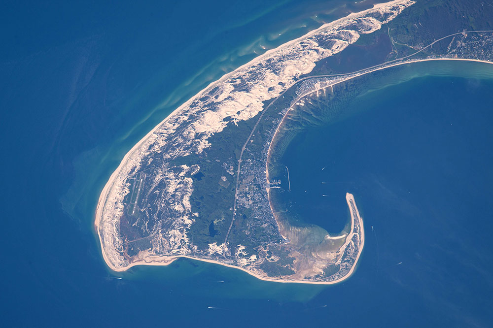
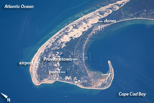
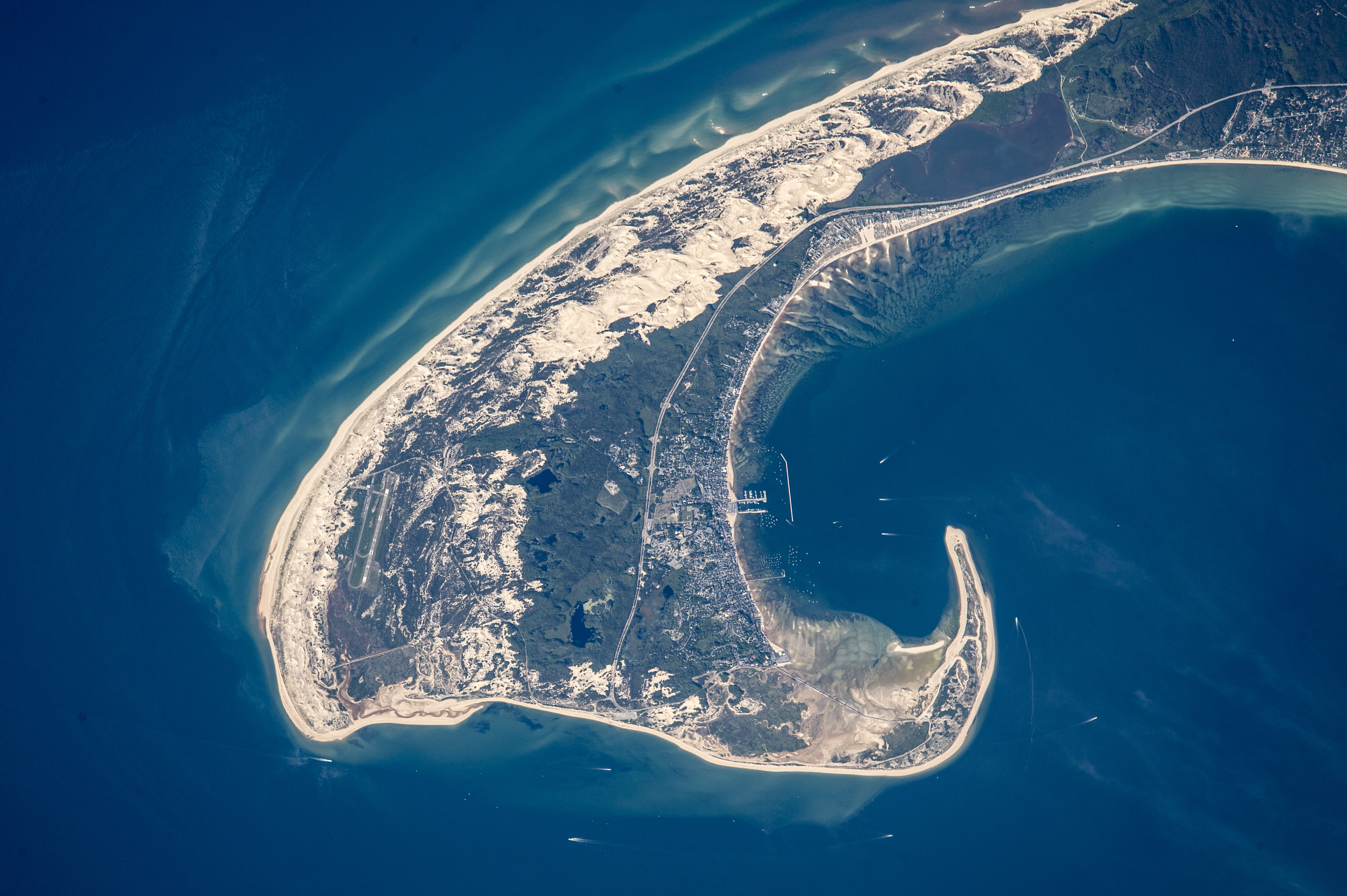
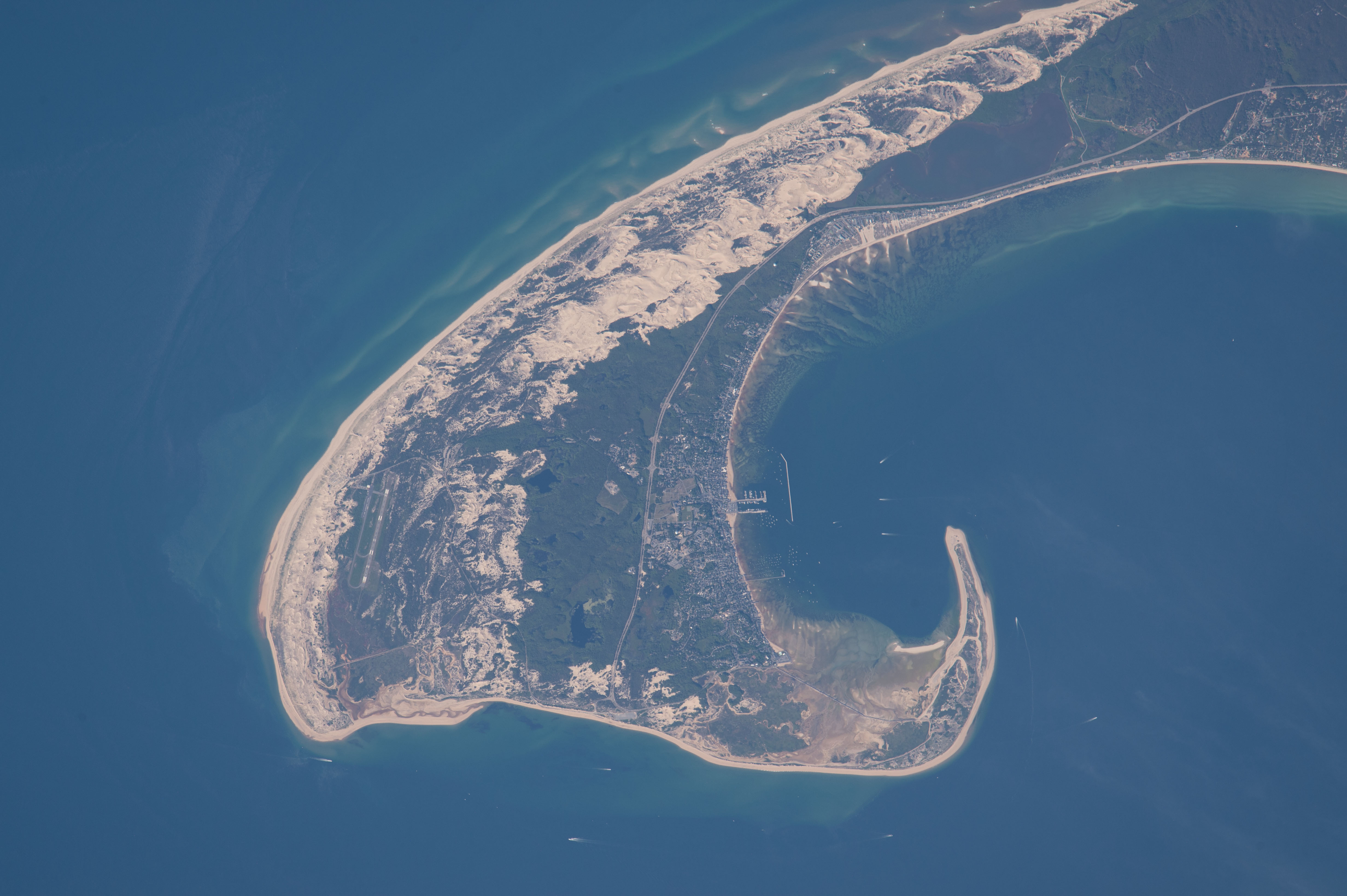
Image Caption: Cape Cod, Massachusetts
Astronauts aboard the International Space Station used a very long lens to shoot this detailed image of the northern tip of Cape Cod--showing 8.5 miles (14 km) of its 65-mile (105 km) length. Cape Cod is one of the biggest barrier islands in the world, and it protects towns like Provincetown and its port facilities (image center) from storm waves coming in from the Atlantic Ocean. It thus also protects much of the Massachusetts coastline. The cream-colored features are symmetrically shaped dunes built mainly by northwesterly winter winds (image upper center) blowing beach sands inland.
In terms of geological age, Cape Cod is young, having been laid down about 20,000 years ago by glaciers when these were at their fullest extent. Even though Cape Cod today has water on both sides, it consists of moraine and associated river deposits laid down by two large lobes of ice that extended into the area from Canada (i.e, out of the image upper left). Strange as it seems today, one great ice lobe lay to the seaward side of the cape, and another on the Cape Cod Bay side. Many ponds (image center) remain on Cape Cod as a result of the receding glacier (image center).
Why is the cape shaped the way it is? When the glaciers were at their fullest extent sea level was more than one hundred meters (more than 325 feet) lower than it is today--because so much water was bound up in huge continental ice sheets. As the ice melted, sea level kept rising and areas that had been covered by ice were submerged under the rising Atlantic waters. At this point waves and sea currents started to erode the moraines and river deposits of the cape. Because it juts out into the Atlantic Ocean, the cape shoreline is heavily eroded by waves. Sometimes the ocean breaks through the barrier island as happened during Hurricane Bob in 1991. In this image, the strong wave erosion has smoothed the beachline facing the Atlantic Ocean. The sands eroded by the waves have been swept northward to feed the growth of the cape.
When a sandy coastal spit like Cape Cod advances into deeper water it grows more slowly and wave action starts to bend the line of spit growth inshore. In the extreme case of Cape Cod, this wave refraction around the tip has turned the growth direction progressively to the west, and then to the south (image lower left and image bottom respectively)--forming the hook shape we see today.
