ISS043-E-123891

| NASA Photo ID | ISS043-E-123891 |
| Focal Length | 170mm |
| Date taken | 2015.04.18 |
| Time taken | 22:05:05 GMT |
1000 x 666 pixels 540 x 360 pixels 4928 x 3280 pixels 720 x 480 pixels 4928 x 3280 pixels 640 x 426 pixels
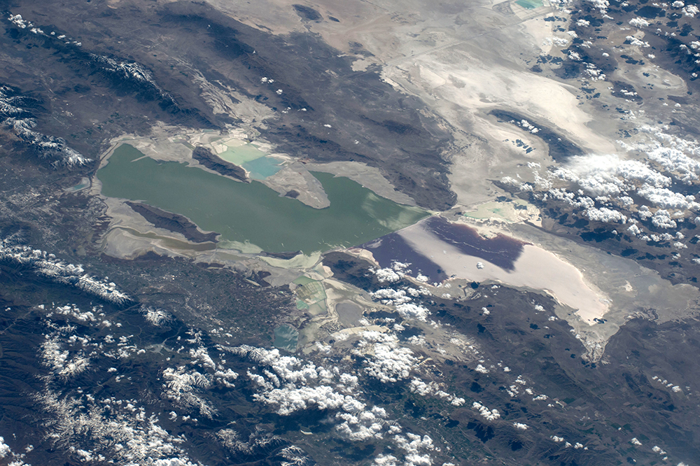
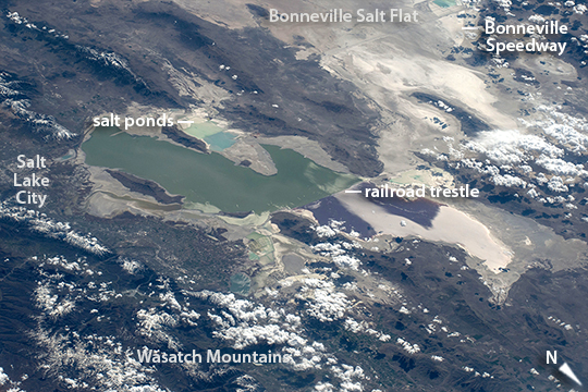

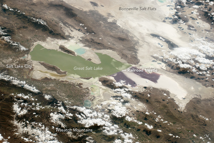
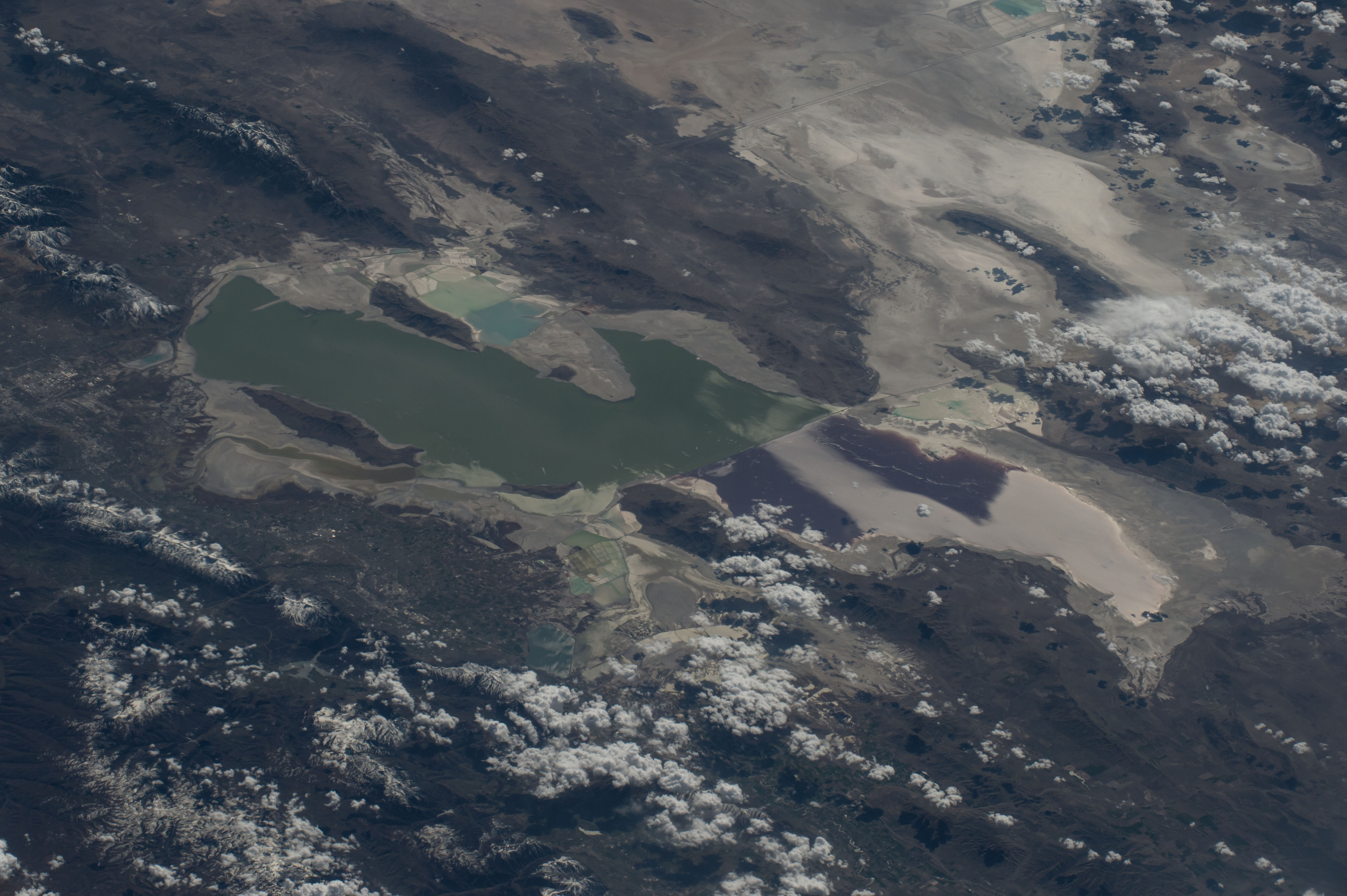

Photo center point: 41.2° N, 112.6° W
Photo center point by machine learning:
Country or Geographic Name: | USA-UTAH |
Features: | GREAT SALT LAKE, BONNEVILLE FLATS |
| Features Found Using Machine Learning: | SALT LAKE CITY |
Cloud Cover Percentage: | 10 (1-10)% |
Sun Elevation Angle: | 40° |
Sun Azimuth: | 242° |
Camera: | Nikon D4 Electronic Still Camera |
Focal Length: | 170mm |
Camera Tilt: | High Oblique |
Format: | 4928E: 4928 x 3280 pixel CMOS sensor, 36.0mm x 23.9mm, total pixels: 16.6 million, Nikon FX format |
Film Exposure: | |
| Additional Information | |
| Width | Height | Annotated | Cropped | Purpose | Links |
|---|---|---|---|---|---|
| 1000 pixels | 666 pixels | No | No | Earth From Space collection | Download Image |
| 540 pixels | 360 pixels | Yes | No | Earth From Space collection | Download Image |
| 4928 pixels | 3280 pixels | No | No | NASA's Earth Observatory web site | Download Image |
| 720 pixels | 480 pixels | Yes | No | NASA's Earth Observatory web site | Download Image |
| 4928 pixels | 3280 pixels | No | No | Download Image | |
| 640 pixels | 426 pixels | No | No | Download Image |
On orbit over the Rocky Mountains, an astronaut aboard the International Space Station took this oblique view of Great Salt Lake (image center) and the white Bonneville Flats beyond (image top right). The lake is unique as seen from orbit because its two halves are different colors--and because the railroad causeway that divides it is a straight line aligned exactly east-west. Small rectangular patterns on both sides of the lake are evaporation ponds from which various salts are collected in commercial operations. Cities are hard to detect in daylight views from space, and Salt Lake City (image left) is almost invisible compared to the night view.
The causeway on which the railroad lies bisects the original circulation of this shallow desert lake (only two small culverts under the causeway join the two halves), so that the water in each half now has different salt concentrations and different temperatures. The result appears as the color difference, because the north basin is saltier and its salt-loving algae color the water shades of red--in this view a dark red-brown (image center). The south basin typically has algae that color the water green (image left).
From their vantage point astronauts can see Great Salt Lake as the remnant of a much larger lake that used to cover the entire Bonneville Flats, and other valleys in most of the state of Utah. Part of the Bonneville Flats appear at the top of the image. Water would have covered most of the view shown here, except for the Wasatch Mountains range (image lower left) and other isolated peaks that would have appeared as islands. Ancient Lake Bonneville, as it has been named, was nearly as large as Lake Michigan and existed from 32,000 to 14,000 years ago--"yesterday" in geological terms, during the last ice age when lower evaporation and meltwater from numerous glaciers allowed the lake to form.
The white, salt-encrusted floor of the ancient lake has been used by racing enthusiasts for decades--the Bonneville Speedway appears image top right. This is the location where many land speed records have been set, and where annual races for all kinds of vehicles take place.
