ISS043-E-101953
| NASA Photo ID | ISS043-E-101953 |
| Focal Length | 800mm |
| Date taken | 2015.04.12 |
| Time taken | 13:18:57 GMT |
Resolutions offered for this image:
1000 x 739 pixels 540 x 399 pixels 4928 x 3280 pixels 720 x 480 pixels 720 x 480 pixels 4928 x 3280 pixels 640 x 426 pixels
1000 x 739 pixels 540 x 399 pixels 4928 x 3280 pixels 720 x 480 pixels 720 x 480 pixels 4928 x 3280 pixels 640 x 426 pixels


Spacecraft nadir point: 22.7° N, 31.0° E
Photo center point: 24.0° N, 32.9° E
Photo center point by machine learning:
Photo center point: 24.0° N, 32.9° E
Photo center point by machine learning:
Nadir to Photo Center: Northeast
Spacecraft Altitude: 217 nautical miles (402km)
Country or Geographic Name: | EGYPT |
Features: | ASWAN HIGH DAM, L. NASSER, AIRPORT |
| Features Found Using Machine Learning: | |
Cloud Cover Percentage: | 10 (1-10)% |
Sun Elevation Angle: | 40° |
Sun Azimuth: | 262° |
Camera: | Nikon D4 Electronic Still Camera |
Focal Length: | 800mm |
Camera Tilt: | 32 degrees |
Format: | 4928E: 4928 x 3280 pixel CMOS sensor, 36.0mm x 23.9mm, total pixels: 16.6 million, Nikon FX format |
Film Exposure: | |
| Additional Information | |
| Width | Height | Annotated | Cropped | Purpose | Links |
|---|---|---|---|---|---|
| 1000 pixels | 739 pixels | No | Yes | Earth From Space collection | Download Image |
| 540 pixels | 399 pixels | Yes | Yes | Earth From Space collection | Download Image |
| 4928 pixels | 3280 pixels | No | No | NASA's Earth Observatory web site | Download Image |
| 720 pixels | 480 pixels | Yes | Yes | NASA's Earth Observatory web site | Download Image |
| 720 pixels | 480 pixels | Yes | Yes | NASA's Earth Observatory web site | Download Image |
| 4928 pixels | 3280 pixels | No | No | Download Image | |
| 640 pixels | 426 pixels | No | No | Download Image |
Download Packaged File
Download a Google Earth KML for this Image
View photo footprint information
Download a GeoTIFF for this photo
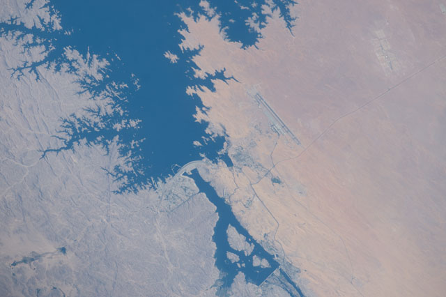
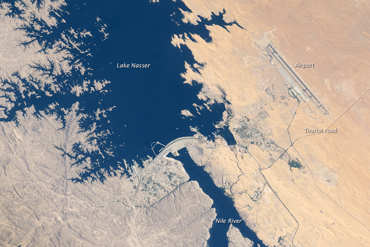
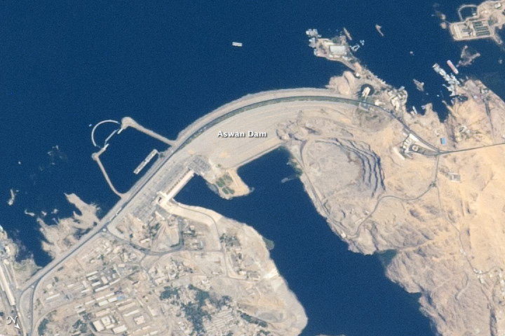
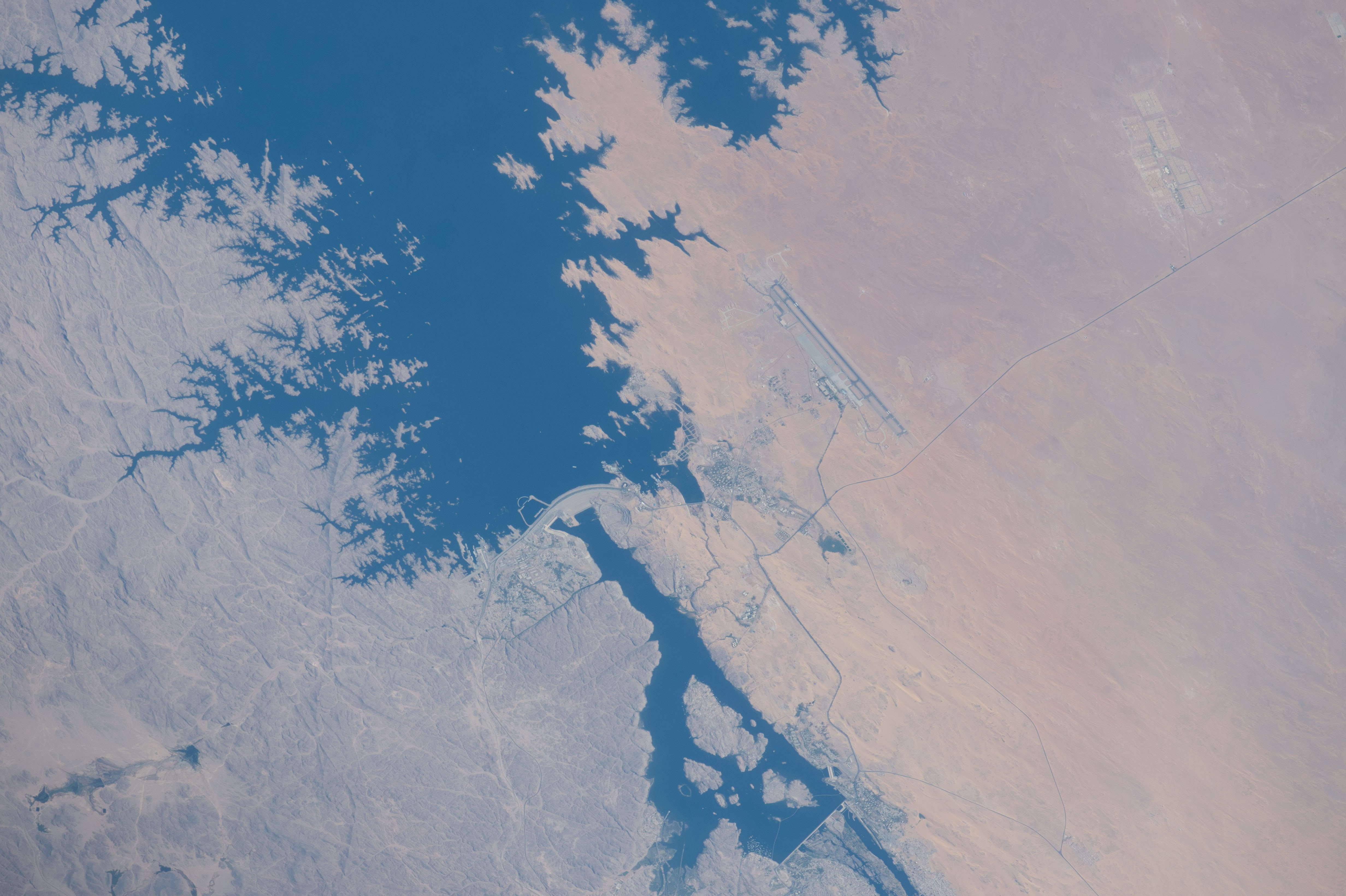
Image Caption: Aswan High Dam, southern Egypt
Astronauts aboard the International Space Station used a high magnification lens to capture the detail of the Aswan High Dam region of the River Nile in southern Egypt, a vast engineering project built between 1960 and 1970 (the Aswan Low Dam, outside the image lower right, was completed in 1902). The highly indented shoreline of 550 km-long (340 mi) Lake Nasser is a familiar sight to space-farers. Aswan International Airport lies due west near the settlement that hosts Aswan University.
Completed in 1970, the Aswan High Dam is one of the largest earthen embankment dams in the world--12,565 feet (3830 m) long and nearly 3281 feet (1000 m) wide--and holds back 132 cubic km (31.7 cubic mi) of water in Lake Nasser. Hydropower generated at the dam wall provides 2.1 gigawatts, fully half of Egypt's needs when the dam was first completed (about 15% by 1998, with population growth), giving numerous villages access to electricity for the first time. The dam has virtually eliminated the danger of floods downstream in the Nile valley.
Building the new reservoir necessitated the relocation not only of nearly 100,000 residents, but also of four famous archaeological sites that were reconstructed in sites above the lake level. A "tourist road" that passes near the airstrip (image right) leads to the massive rock temple of Abu Simbel (outside the image), built by Pharaoh Ramses II in the 13th century BCE. The temple was reassembled above the shoreline of Lake Nasser.
