ISS042-E-178671

| NASA Photo ID | ISS042-E-178671 |
| Focal Length | 70mm |
| Date taken | 2015.01.24 |
| Time taken | 06:12:53 GMT |
Resolutions offered for this image:
1000 x 666 pixels 540 x 360 pixels 4928 x 3280 pixels 720 x 480 pixels 4928 x 3280 pixels 640 x 426 pixels
1000 x 666 pixels 540 x 360 pixels 4928 x 3280 pixels 720 x 480 pixels 4928 x 3280 pixels 640 x 426 pixels


Spacecraft nadir point: 40.4° S, 175.8° W
Photo center point: 41.5° S, 174.5° E
Photo center point by machine learning:
Photo center point: 41.5° S, 174.5° E
Photo center point by machine learning:
Nadir to Photo Center: West
Spacecraft Altitude: 219 nautical miles (406km)
Country or Geographic Name: | NEW ZEALAND-SI |
Features: | PAN-SOUTH I., COOK STR., GLINT |
| Features Found Using Machine Learning: | PAN- |
Cloud Cover Percentage: | 10 (1-10)% |
Sun Elevation Angle: | 9° |
Sun Azimuth: | 252° |
Camera: | Nikon D4 Electronic Still Camera |
Focal Length: | 70mm |
Camera Tilt: | High Oblique |
Format: | 4928E: 4928 x 3280 pixel CMOS sensor, 36.0mm x 23.9mm, total pixels: 16.6 million, Nikon FX format |
Film Exposure: | |
| Additional Information | |
| Width | Height | Annotated | Cropped | Purpose | Links |
|---|---|---|---|---|---|
| 1000 pixels | 666 pixels | No | No | Earth From Space collection | Download Image |
| 540 pixels | 360 pixels | Yes | No | Earth From Space collection | Download Image |
| 4928 pixels | 3280 pixels | No | No | NASA's Earth Observatory web site | Download Image |
| 720 pixels | 480 pixels | Yes | No | NASA's Earth Observatory web site | Download Image |
| 4928 pixels | 3280 pixels | No | No | Download Image | |
| 640 pixels | 426 pixels | No | No | Download Image |
Download Packaged File
Download a Google Earth KML for this Image
View photo footprint information
Download a GeoTIFF for this photo
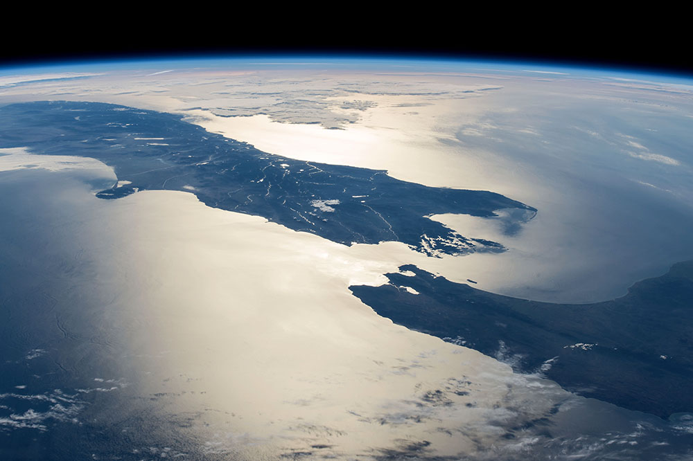
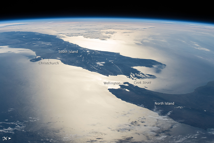
Image Caption: New Zealand in sunglint
In this panoramic image taken by astronauts aboard the International Space Station (ISS), the sun's glint point highlights the detail of Cook Strait between New Zealand's North and South Islands. Crews looking west towards a setting sun were able to see this high-contrast detail even though the center of the glint point lay fully 1000 km away from the ISS.
Sunglint shows Wellington Bay (image center) -- where the capital city is located -- opening onto Cook Strait. Banks Peninsula, near the city of Christchurch, is the prominent cape (image left) whose characteristic shape is well known to ISS crews. Approaching cloud can be seen image top left. New Zealand is seldom photographed from orbit because it is one of the cloudier parts of planet, and because scheduled crew sleep periods often occur when the ISS passes over this part of the planet.
