ISS040-E-081320
| NASA Photo ID | ISS040-E-081320 |
| Focal Length | 28mm |
| Date taken | 2014.07.26 |
| Time taken | 23:54:25 GMT |

Cloud masks available for this image:
Spacecraft nadir point: 31.7° N, 11.9° W
Photo center point:
Photo center point by machine learning:
Photo center point:
Photo center point by machine learning:
Nadir to Photo Center:
Spacecraft Altitude: 223 nautical miles (413km)
Country or Geographic Name: | |
Features: | |
| Features Found Using Machine Learning: | PAN- |
Cloud Cover Percentage: | 0 (no clouds present) |
Sun Elevation Angle: | -37° |
Sun Azimuth: | 342° |
Camera: | NIKON D3S S/N: 2007931 |
Focal Length: | 28mm |
Camera Tilt: | |
Format: | |
Film Exposure: | |
| Additional Information | |
| Width | Height | Annotated | Cropped | Purpose | Links |
|---|---|---|---|---|---|
| 4256 pixels | 2832 pixels | No | No | Download Image | |
| 640 pixels | 426 pixels | No | No | Download Image |
Download Packaged File
Download a Google Earth KML for this Image
View photo footprint information
Download a GeoTIFF for this photo
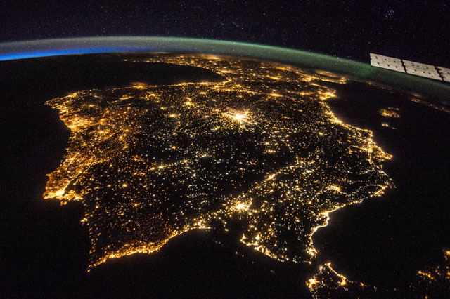
Image Caption: ISS040-E-081320 (26 July 2014) --- One of the Expedition 40 crew members aboard the International Space Station recorded this early evening photo of the entire Iberian Peninsula (Spain and Portugal) on July 26, 2014. Part of France can be seen at the top of the image and the Strait of Gibraltar is visible at bottom, with a very small portion of Morocco visible near the lower right corner.
