ISS039-E-20171

| NASA Photo ID | ISS039-E-20171 |
| Focal Length | 80mm |
| Date taken | 2014.05.07 |
| Time taken | 10:29:04 GMT |
1000 x 665 pixels 540 x 359 pixels 4256 x 2832 pixels 720 x 480 pixels 4256 x 2832 pixels 640 x 426 pixels

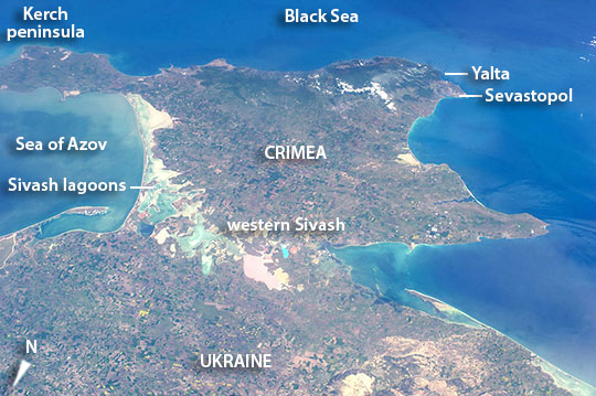


Photo center point: 45.5° N, 34.0° E
Photo center point by machine learning:
Country or Geographic Name: | UKRAINE |
Features: | CRIMEAN PEN., SIVASH L., BLACK SEA |
| Features Found Using Machine Learning: | |
Cloud Cover Percentage: | 10 (1-10)% |
Sun Elevation Angle: | 56° |
Sun Azimuth: | 202° |
Camera: | Nikon D3S Electronic Still Camera |
Focal Length: | 80mm |
Camera Tilt: | 44 degrees |
Format: | 4256E: 4256 x 2832 pixel CMOS sensor, 36.0mm x 23.9mm, total pixels: 12.87 million, Nikon FX format |
Film Exposure: | |
| Additional Information | |
| Width | Height | Annotated | Cropped | Purpose | Links |
|---|---|---|---|---|---|
| 1000 pixels | 665 pixels | No | No | Earth From Space collection | Download Image |
| 540 pixels | 359 pixels | Yes | No | Earth From Space collection | Download Image |
| 4256 pixels | 2832 pixels | No | No | NASA's Earth Observatory web site | Download Image |
| 720 pixels | 480 pixels | Yes | No | NASA's Earth Observatory web site | Download Image |
| 4256 pixels | 2832 pixels | No | No | Download Image | |
| 640 pixels | 426 pixels | No | No | Download Image |
An astronaut aboard the International Space Station used a short lens to gain this wide view of the entire diamond-shaped Crimean Peninsula that juts into the Black Sea. A series of shallow lagoons and wetlands known as the Sivash lakes separates the peninsula from the mainland (Ukraine). Being only up to 3 m deep, these lagoons warm up in summer and become very salty due to evaporation. Especially in the west, further from the Sea of Azov, they develop different colors (image lower center) as a result of the salt-tolerant algae that live in the salty water. These western Sivash lagoons make a unique landscape as seen from space that immediately indicate to astronauts that are near Crimea.
Crimea is a small part of the world (325 km from in an east-west direction) but one that has acquired fame over the centuries. The mild climate has made it a popular destination for Ukrainians and Russians from colder climes to the north. Sevastopol saw heavy fighting between the Russians and Germans in WWII. Yalta is the city where Allied leaders met together for a famous conference late in WWII to discuss post-war arrangements. Balaklava, near Sevastopol, is a city made famous during the Crimean War of the 1850s for the suicidal Charge of the Light Brigade--and for the head and neck garment known as the balaklava where soldiers first wore the garment. Sevastopol is also the home port of Russia's Black Sea Fleet, whose location was one of the causes for Russia's annexation of the peninsula from Ukraine in 2014.
An image taken 2 seconds later shows the Strait of Kerch (just outside this image far left) is the shipping route that connects the Sea of Azov with the Black Sea.
