ISS037-E-15305

| NASA Photo ID | ISS037-E-15305 |
| Focal Length | 180mm |
| Date taken | 2013.10.17 |
| Time taken | 20:51:32 GMT |
1000 x 665 pixels 540 x 359 pixels 2128 x 1416 pixels 720 x 480 pixels 4256 x 2832 pixels 640 x 426 pixels
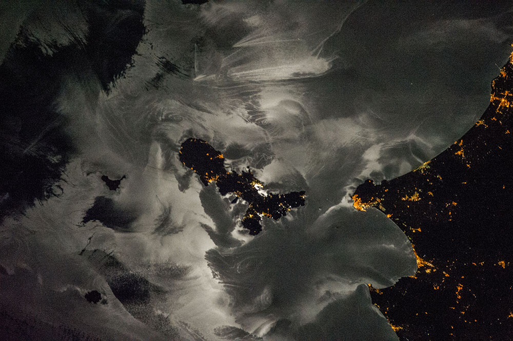


Photo center point: 42.8° N, 10.3° E
Photo center point by machine learning:
Country or Geographic Name: | ITALY |
Features: | ELBA-PIOMBINO-FOLLONICA AREA AT NIGHT, MOON GLINT ON SEA SURFACE |
| Features Found Using Machine Learning: | |
Cloud Cover Percentage: | 10 (1-10)% |
Sun Elevation Angle: | -44° |
Sun Azimuth: | 309° |
Camera: | Nikon D3S Electronic Still Camera |
Focal Length: | 180mm |
Camera Tilt: | 39 degrees |
Format: | 4256E: 4256 x 2832 pixel CMOS sensor, 36.0mm x 23.9mm, total pixels: 12.87 million, Nikon FX format |
Film Exposure: | |
| Additional Information | |
| Width | Height | Annotated | Cropped | Purpose | Links |
|---|---|---|---|---|---|
| 1000 pixels | 665 pixels | No | No | Earth From Space collection | Download Image |
| 540 pixels | 359 pixels | Yes | No | Earth From Space collection | Download Image |
| 2128 pixels | 1416 pixels | No | No | NASA's Earth Observatory web site | Download Image |
| 720 pixels | 480 pixels | Yes | No | NASA's Earth Observatory web site | Download Image |
| 4256 pixels | 2832 pixels | No | No | Download Image | |
| 640 pixels | 426 pixels | No | No | Download Image |
Part of the astronaut experience is seeing the planet transform from day to night, in ways that earth-bound people usually never see. A crew member aboard the International Space Station took this image of the northern Mediterranean Sea, centered on the island of Elba, with city lights of the Italian towns of Piombino and Punta Ala image right. Shooting towards the reflection of the moon on the sea surface, moonglint reveals the highly complex patterns on the sea surface--in the night equivalent of sunglint. The strongest reflection is near the center of the moon's disc, which brightens the sea surface around the island of Elba. But in the complex patterns seen from space, the dark areas of the sea surface even make the islands like Elba, Montecristo (lower left) and Pianosa (left) more difficult to see.
The reflection off sea surfaces captures many different processes, mostly natural processes, but some made by humans. Waves trailing behind ships passing north of Elba make the classic V-shaped pattern (image top). The meandering line coming off Montecristo Island is an "island wake," made up of alternating vortices of wind that develop on the downwind side of the island. This wake is the strongest evidence that a northeast wind was blowing (that is, right to left) on this October midnight. A shorter meandering wind pattern is being shed off Punta Ala on the mainland (image lower right). Smoother surfaces, protected from wind, are usually brighter, being a better mirror for moonlight.
The sea surface also displays numerous tight swirls known as gyres (three examples are indicated by arrows; there are several in the field of view). The broad swath of parallel lines image at image top left are probably part of the larger circulation of the sea, which usually experiences north-flowing currents around Elba..
