ISS036-E-11034

| NASA Photo ID | ISS036-E-11034 |
| Focal Length | 50mm |
| Date taken | 2013.06.21 |
| Time taken | 21:15:31 GMT |
Resolutions offered for this image:
1000 x 665 pixels 540 x 359 pixels 1440 x 960 pixels 720 x 480 pixels 4256 x 2832 pixels 640 x 426 pixels
1000 x 665 pixels 540 x 359 pixels 1440 x 960 pixels 720 x 480 pixels 4256 x 2832 pixels 640 x 426 pixels


Spacecraft nadir point: 31.4° N, 115.4° W
Photo center point: 32.5° N, 115.5° W
Photo center point by machine learning:
Photo center point: 32.5° N, 115.5° W
Photo center point by machine learning:
Nadir to Photo Center: North
Spacecraft Altitude: 220 nautical miles (407km)
Country or Geographic Name: | MEXICO |
Features: | YUMA, SAN DIEGO, MEXICALI, SALTON SEA, COLORADO RIVER DELTA, TIJUANA |
| Features Found Using Machine Learning: | |
Cloud Cover Percentage: | 10 (1-10)% |
Sun Elevation Angle: | 68° |
Sun Azimuth: | 255° |
Camera: | Nikon D3S Electronic Still Camera |
Focal Length: | 50mm |
Camera Tilt: | 17 degrees |
Format: | 4256E: 4256 x 2832 pixel CMOS sensor, 36.0mm x 23.9mm, total pixels: 12.87 million, Nikon FX format |
Film Exposure: | |
| Additional Information | |
| Width | Height | Annotated | Cropped | Purpose | Links |
|---|---|---|---|---|---|
| 1000 pixels | 665 pixels | No | Yes | Earth From Space collection | Download Image |
| 540 pixels | 359 pixels | Yes | Yes | Earth From Space collection | Download Image |
| 1440 pixels | 960 pixels | No | Yes | NASA's Earth Observatory web site | Download Image |
| 720 pixels | 480 pixels | Yes | No | NASA's Earth Observatory web site | Download Image |
| 4256 pixels | 2832 pixels | No | No | Download Image | |
| 640 pixels | 426 pixels | No | No | Download Image |
Download Packaged File
Download a Google Earth KML for this Image
View photo footprint information
Download a GeoTIFF for this photo
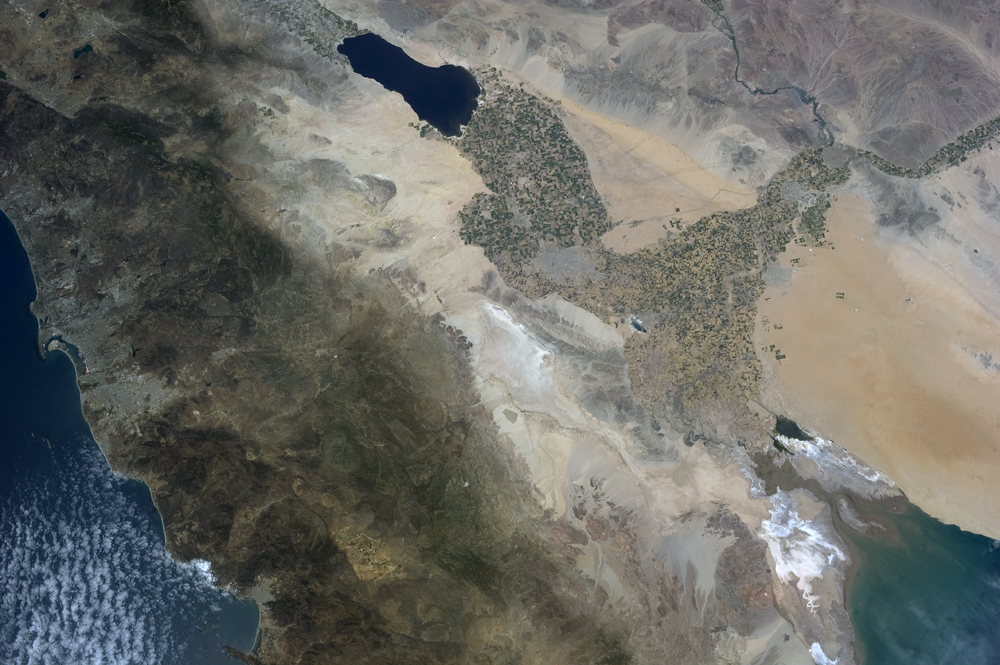
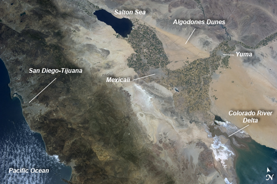
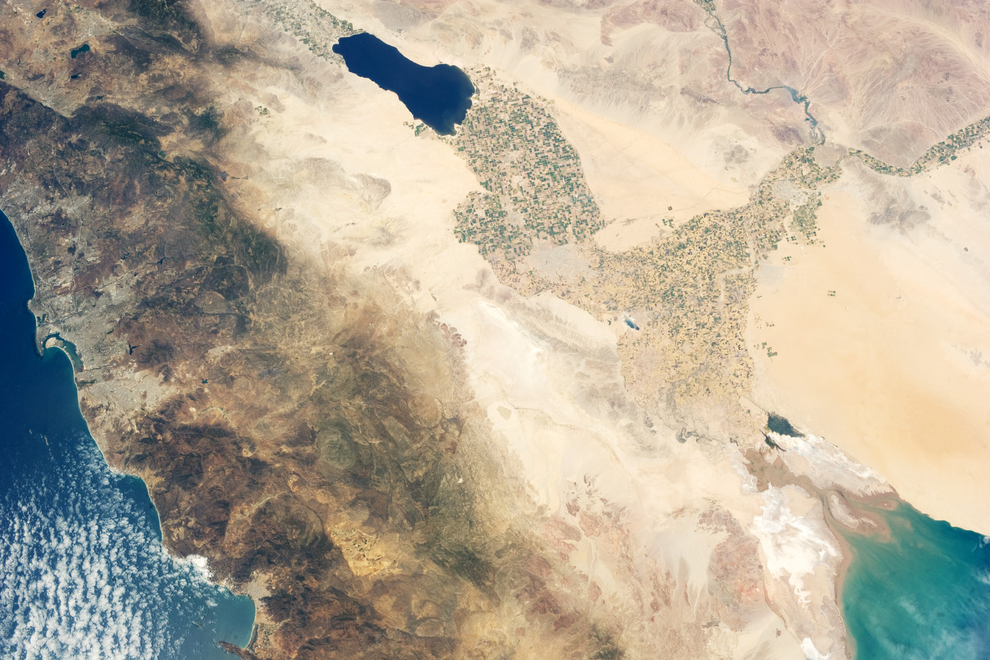
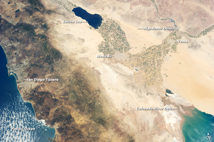
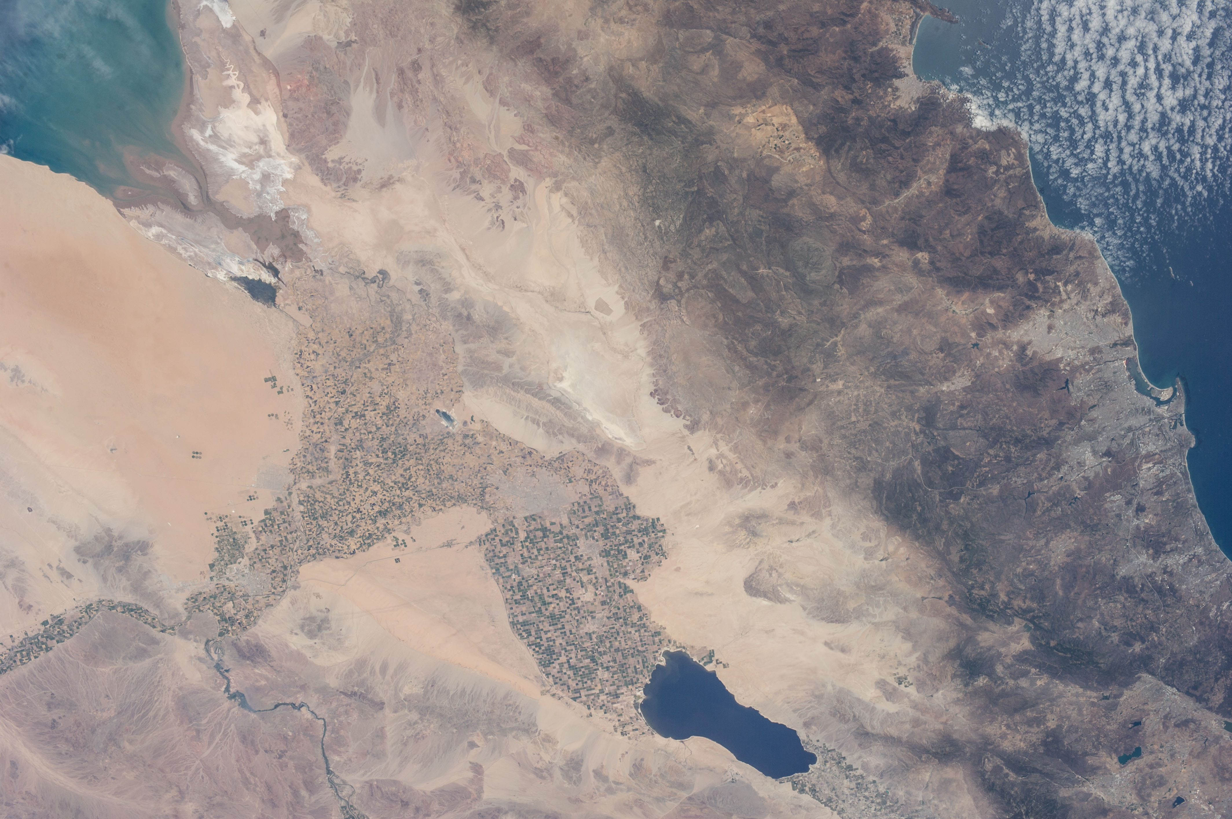
Image Caption: Salton Trough, USA and Mexico
Note: This caption refers to the image versions labeled "NASA's Earth Observatory web site".
The Imperial and Coachella Valleys of southern California - and the corresponding Mexicali Valley and Colorado River Delta in Mexico - are part of the Salton Trough, a large geologic structure known to geologists as a graben or rift valley that extends into the Gulf of California. The trough is a geologically complex zone formed by interaction of the San Andreas transform fault system that is, broadly speaking, moving southern California towards Alaska; and the northward motion of the Gulf of California segment of the East Pacific Rise that continues to widen the Gulf of California by sea-floor spreading.
Sediments deposited by the Colorado River have been filling the northern rift valley (the Salton Trough) for the past several million years, excluding the waters of the Gulf of California and providing a fertile environment - together with irrigation--for the development of extensive agriculture in the region (visible as green and yellow-brown fields at image center). The Salton Sea, a favorite landmark of astronauts in low earth orbit, was formed by an irrigation canal rupture in 1905, and today is sustained by agricultural runoff water.
A wide array of varying landforms and land uses in the Salton Trough are visible from space. In addition to the agricultural fields and Salton Sea, easily visible metropolitan areas include Yuma, AZ (image top left); Mexicali, Baja California, Mexico(image center); and the San Diego-Tijuana conurbation on the Pacific Coast (image left). The approximately 72 kilometer long Algodones Dunefield is visible at image top right.
