ISS030-E-10008
| NASA Photo ID | ISS030-E-10008 |
| Focal Length | 24mm |
| Date taken | 2011.12.04 |
| Time taken | 00:13:44 GMT |
Resolutions offered for this image:
1000 x 665 pixels 540 x 359 pixels 720 x 480 pixels 4256 x 2832 pixels 640 x 426 pixels
1000 x 665 pixels 540 x 359 pixels 720 x 480 pixels 4256 x 2832 pixels 640 x 426 pixels


Cloud masks available for this image:
Spacecraft nadir point: 36.6° N, 13.9° W
Photo center point: 40.5° N, 5.0° W
Photo center point by machine learning:
Photo center point: 40.5° N, 5.0° W
Photo center point by machine learning:
Nadir to Photo Center: East
Spacecraft Altitude: 206 nautical miles (382km)
Country or Geographic Name: | SPAIN |
Features: | LISBON AT NIGHT, MADRID AT NIGHT, SEVILLE AT NIGHT, IBERIAN PENINSULA AT NIGHT |
| Features Found Using Machine Learning: | PAN- |
Cloud Cover Percentage: | 25 (11-25)% |
Sun Elevation Angle: | -74° |
Sun Azimuth: | 332° |
Camera: | Nikon D3S Electronic Still Camera |
Focal Length: | 24mm |
Camera Tilt: | High Oblique |
Format: | 4256E: 4256 x 2832 pixel CMOS sensor, 36.0mm x 23.9mm, total pixels: 12.87 million, Nikon FX format |
Film Exposure: | |
| Additional Information | |
This photo is one of the photos used to create this time-lapse video:
| Width | Height | Annotated | Cropped | Purpose | Links |
|---|---|---|---|---|---|
| 1000 pixels | 665 pixels | No | Yes | Earth From Space collection | Download Image |
| 540 pixels | 359 pixels | Yes | Yes | Earth From Space collection | Download Image |
| 720 pixels | 480 pixels | Yes | Yes | NASA's Earth Observatory web site | Download Image |
| 4256 pixels | 2832 pixels | No | No | Download Image | |
| 640 pixels | 426 pixels | No | No | Download Image |
Download Packaged File
Download a Google Earth KML for this Image
View photo footprint information
Download a GeoTIFF for this photo
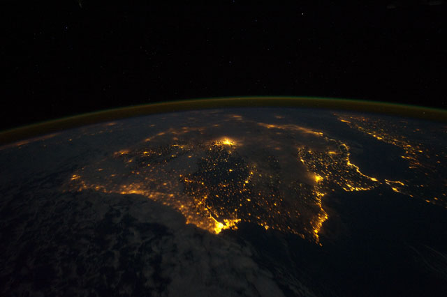
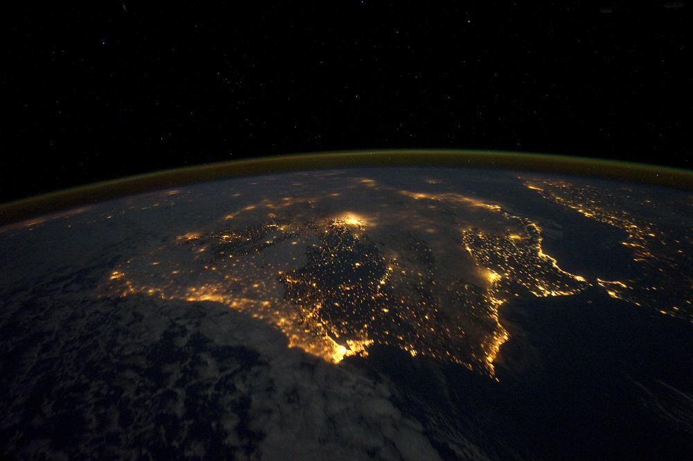
Image Caption: Iberian Peninsula at Night
The city lights of Spain and Portugal define the Iberian Peninsula in this astronaut photograph taken from the International Space Station (ISS). Several large metropolitan areas are visible, marked by their relatively large and brightly lit areas, such as the capital cities of Madrid, Spain-located near the center of the peninsula's interior--and Lisbon, Portugal--located along the southwestern coastline. The ancient city of Seville, visible at image right to the north of the approximately 14 kilometer-wide Strait of Gibraltar, is one of the largest cities in Spain. The view is looking outwards from the ISS towards the east.
The network of smaller cities and towns in the interior and along the coastline attest to the areal extent of human presence on the Iberian landscape. Blurring of the city lights is caused by thin cloud cover (image left and center), while the cloud tops are dimly illuminated by moonlight. Though obscured, the lights of France are visible near the horizon line at image upper left, while the lights of northern Africa are more clearly discernable at image right. The gold to green line of airglow, caused by excitation of upper atmosphere gas molecules by ultraviolet radiation, parallels the horizon line (or Earth limb).
The Iberian Peninsula is the southwestern-most of the three European peninsulas (together with the Italian and Balkan peninsulas), and includes the Principality of Andorra as well as the Kingdom of Spain and the Portuguese Republic. The approximately 590,000 square kilometer landmass is bounded by the Atlantic Ocean to the northwest, west, and southwest and the Mediterranean Sea to the east. Its northeastern boundary with the rest of continental Europe is marked by the Pyrenees mountain range.
