ISS015-E-7543
| NASA Photo ID | ISS015-E-7543 |
| Focal Length | 800mm |
| Date taken | 2007.05.10 |
| Time taken | 21:43:29 GMT |
Resolutions offered for this image:
1000 x 750 pixels 540 x 405 pixels 3032 x 2064 pixels 639 x 435 pixels
1000 x 750 pixels 540 x 405 pixels 3032 x 2064 pixels 639 x 435 pixels

Cloud masks available for this image:
Spacecraft nadir point: 6.5° N, 82.8° W
Photo center point: 11.5° N, 85.6° W
Photo center point by machine learning:
Photo center point: 11.5° N, 85.6° W
Photo center point by machine learning:
Nadir to Photo Center: Northwest
Spacecraft Altitude: 178 nautical miles (330km)
Country or Geographic Name: | NICARAGUA |
Features: | CONCEPCION VOLCANO, PLUME |
| Features Found Using Machine Learning: | |
Cloud Cover Percentage: | 10 (1-10)% |
Sun Elevation Angle: | 27° |
Sun Azimuth: | 287° |
Camera: | Kodak DCS760c Electronic Still Camera |
Focal Length: | 800mm |
Camera Tilt: | High Oblique |
Format: | 3060E: 3060 x 2036 pixel CCD, RGBG array |
Film Exposure: | |
| Additional Information | |
| Width | Height | Annotated | Cropped | Purpose | Links |
|---|---|---|---|---|---|
| 1000 pixels | 750 pixels | No | Yes | Earth From Space collection | Download Image |
| 540 pixels | 405 pixels | Yes | Yes | Earth From Space collection | Download Image |
| 3032 pixels | 2064 pixels | No | No | Download Image | |
| 639 pixels | 435 pixels | No | No | Download Image |
Download Packaged File
Download a Google Earth KML for this Image
View photo footprint information
Download a GeoTIFF for this photo
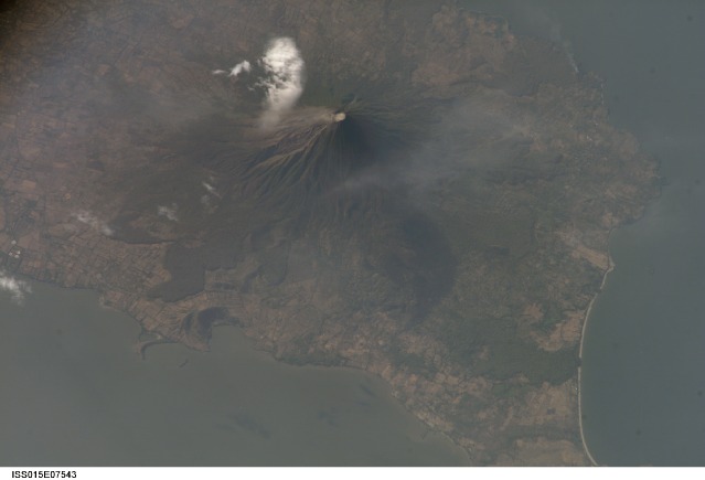
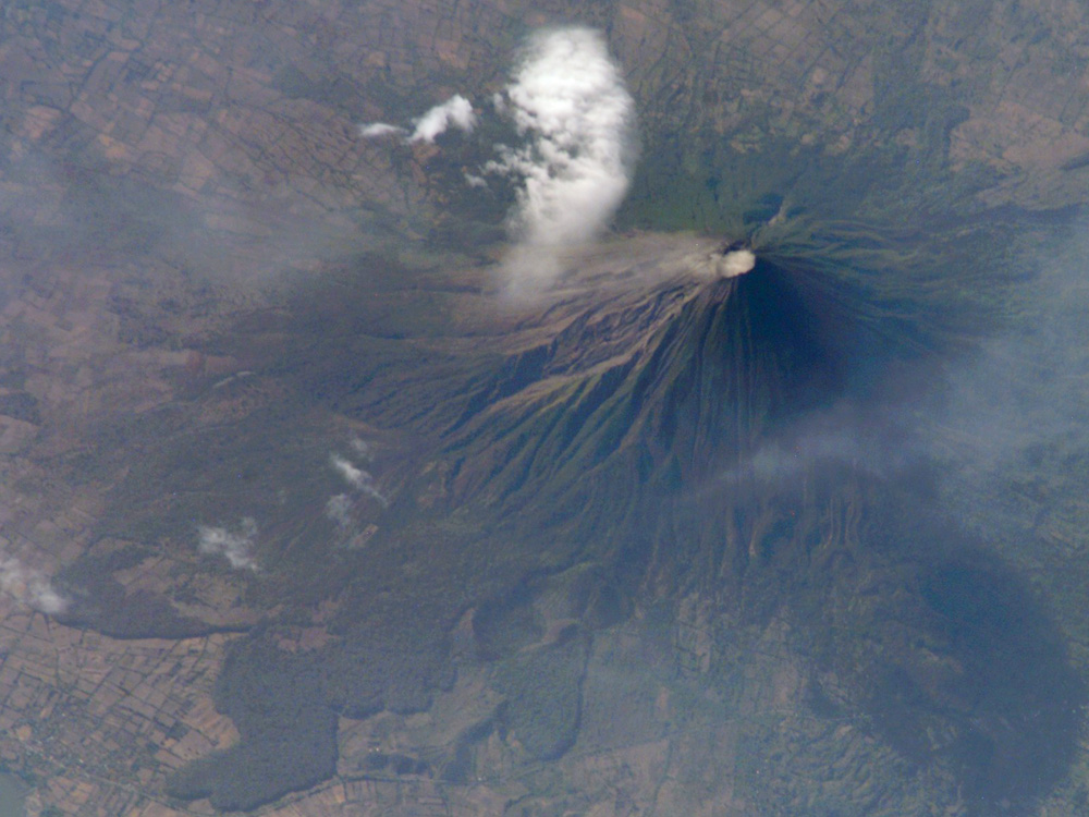
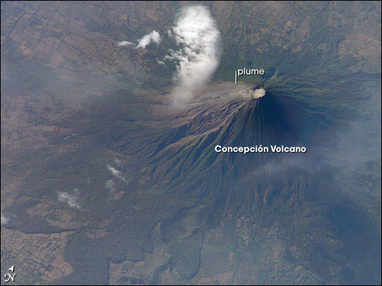
Image Caption: Concepcion Volcano, Nicaragua:
Concepcion Volcano is one of the tallest and most active of Nicaragua's volcanoes. The 1,610-meter (5,280-foot), cone-shaped volcano is the northern half of dumbbell-shaped Isla de Ometepe. Concepcion is joined by a narrow isthmus to the dormant Maderas Volcano, which makes up the southern half of the island. This image of the volcano was captured on May 10, 2007, by the astronauts onboard the International Space Station. To the northwest of the crater, a very faint plume (probably steam) creeps like fog down the mountain, blurring the sharp gullies that carve the volcano's flanks. The grid pattern of people's fields surrounds the volcano, while lobes of forest line the lower slopes.
Concepcion has erupted at least 25 times in the past 125 years, but eruptions are not the only hazard for the 5,000 or so people who lives in small towns at lower elevations. Loose rock and ash from previous eruptions makes the volcano's steep slopes unstable and prone to give way during heavy rains. These flows of muddy debris are known as lahars. Among the most serious lahars that have occurred at Concepcion in recent years were those that occurred during the passage of Hurricane Mitch through the area in 1998. (Much more serious lahars occurred at Nicaragua's Casita Volcano during Hurricane Mitch.) The gullies that can funnel debris quickly downslope into populated areas are obvious in the image.
References and Related images:
Lahar Hazards at Concepcion Volcano, Nicaragua, a U.S. Geological Survey Webpage
Wide-area view of western Nicaragua, including Lake Nicaragua and Isla Ometepe at lower right, from the Moderate Resolution Imaging Spectroradiometer (MODIS) on NASA's Terra satellite
