ISS013-E-44847
| NASA Photo ID | ISS013-E-44847 |
| Focal Length | 800mm |
| Date taken | 2006.06.30 |
| Time taken | 13:17:51 GMT |
Resolutions offered for this image:
1000 x 661 pixels 540 x 357 pixels 540 x 405 pixels 3032 x 2064 pixels 639 x 435 pixels
1000 x 661 pixels 540 x 357 pixels 540 x 405 pixels 3032 x 2064 pixels 639 x 435 pixels


Cloud masks available for this image:
Spacecraft nadir point: 35.4° N, 34.8° E
Photo center point: 31.2° N, 32.3° E
Photo center point by machine learning:
Photo center point: 31.2° N, 32.3° E
Photo center point by machine learning:
Nadir to Photo Center: Southwest
Spacecraft Altitude: 178 nautical miles (330km)
Country or Geographic Name: | EGYPT |
Features: | PORT SAID, SUEZ CANAL, SHIPS |
| Features Found Using Machine Learning: | |
Cloud Cover Percentage: | 10 (1-10)% |
Sun Elevation Angle: | 42° |
Sun Azimuth: | 270° |
Camera: | Kodak DCS760c Electronic Still Camera |
Focal Length: | 800mm |
Camera Tilt: | High Oblique |
Format: | 3060E: 3060 x 2036 pixel CCD, RGBG array |
Film Exposure: | |
| Additional Information | |
| Width | Height | Annotated | Cropped | Purpose | Links |
|---|---|---|---|---|---|
| 1000 pixels | 661 pixels | No | Yes | Earth From Space collection | Download Image |
| 540 pixels | 357 pixels | Yes | Yes | Earth From Space collection | Download Image |
| 540 pixels | 405 pixels | Yes | Yes | NASA's Earth Observatory web site | Download Image |
| 3032 pixels | 2064 pixels | No | No | Download Image | |
| 639 pixels | 435 pixels | No | No | Download Image |
Download Packaged File
Download a Google Earth KML for this Image
View photo footprint information
Download a GeoTIFF for this photo
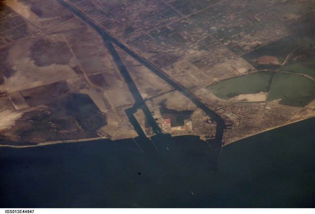
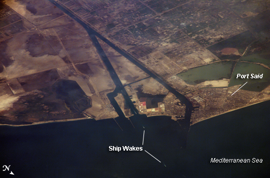
Image Caption: Ship Traffic on the Suez Canal, Egypt
This astronaut photograph captures a northbound convoy of cargo ships entering the Mediterranean Sea from the Suez Canal in Egypt (leftmost canal branch at image center). The Suez Canal connects Port Said on the Mediterranean Sea with the port of Suez on the Red Sea, and provides an essentially direct route for transport of goods between Europe and Asia. The Canal is 163 kilometers (approximately 100 miles) long, and 300 meters (almost 1,000 feet) wide at its narrowest point--wide enough for ships as large as aircraft carriers to traverse it. Transit time from end to end is 14 hours on average.
The Canal was built under the direction of Ferdinand de Lesseps of France using primarily Egyptian labor, and it was opened to traffic in 1869. Subsequent wars and skirmishes have passed control of the Canal to various powers including the United Kingdom, Egypt, Israel, and the United Nations. A multinational observer force including the United States, Israel, and Egypt currently oversees the Canal.
This is an oblique image of the canal, meaning it has been taken at an angle. Astronauts and cosmonauts on the International Space Station (ISS) can photograph the part of the Earth directly below the station as it passes overhead, or they can photograph different parts of the globe. When they photograph different parts of the globe, they take pictures at an angle to provide a sense of perspective. In this case, the ISS was located above the eastern coast of Cyprus, and the astronaut was looking at Egypt to the southwest. Regions of reduced clarity in the image result from thin cloud cover. The day this image was taken, the total number of Earth photographs acquired by astronauts aboard the ISS passed 200,000.
