ISS007-E-7304
| NASA Photo ID | ISS007-E-7304 |
| Focal Length | 16mm |
| Date taken | 2003.06.13 |
| Time taken | 21:16:51 GMT |
Resolutions offered for this image:
3027 x 1998 pixels 1000 x 660 pixels 540 x 334 pixels 3032 x 2064 pixels 639 x 435 pixels
3027 x 1998 pixels 1000 x 660 pixels 540 x 334 pixels 3032 x 2064 pixels 639 x 435 pixels


Cloud masks available for this image:
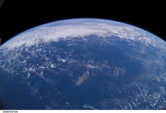
Spacecraft nadir point: 0.4° S, 175.5° E
Photo center point: 7.0° S, 168.0° E
Photo center point by machine learning:
Photo center point: 7.0° S, 168.0° E
Photo center point by machine learning:
Nadir to Photo Center: Southwest
Spacecraft Altitude: 211 nautical miles (391km)
Country or Geographic Name: | PACIFIC OCEAN |
Features: | PAN-CLOUDS, TABITEUEA, ONOTOA |
| Features Found Using Machine Learning: | PAN- |
Cloud Cover Percentage: | 50 (26-50)% |
Sun Elevation Angle: | 40° |
Sun Azimuth: | 59° |
Camera: | Kodak DCS760c Electronic Still Camera |
Focal Length: | 16mm |
Camera Tilt: | High Oblique |
Format: | 3060E: 3060 x 2036 pixel CCD, RGBG array |
Film Exposure: | |
| Additional Information | |
| Width | Height | Annotated | Cropped | Purpose | Links |
|---|---|---|---|---|---|
| 3027 pixels | 1998 pixels | Earth From Space collection | Download Image | ||
| 1000 pixels | 660 pixels | No | Yes | NASA's Earth Observatory web site | Download Image |
| 540 pixels | 334 pixels | Yes | NASA's Earth Observatory web site | Download Image | |
| 3032 pixels | 2064 pixels | No | No | Download Image | |
| 639 pixels | 435 pixels | No | No | Download Image |
Download Packaged File
Download a Google Earth KML for this Image
View photo footprint information
Download a GeoTIFF for this photo
Image Caption: ISS007-E-07304 (13 June 2003) --- This view of Earth's horizon was taken by an Expedition 7 crewmember onboard the International Space Station (ISS), using a wide-angle lens while the Station was over the Pacific Ocean. In the foreground are the atolls of Tabiteuea and Onotoa.
