ISS017-E-7322
| NASA Photo ID | ISS017-E-7322 |
| Focal Length | 400mm |
| Date taken | 2008.05.17 |
| Time taken | 13:46:16 GMT |
Resolutions offered for this image:
1000 x 698 pixels 540 x 377 pixels 540 x 405 pixels 3032 x 2065 pixels 640 x 436 pixels
1000 x 698 pixels 540 x 377 pixels 540 x 405 pixels 3032 x 2065 pixels 640 x 436 pixels


Cloud masks available for this image:
Spacecraft nadir point: 11.2° S, 79.0° W
Photo center point: 10.3° S, 76.9° W
Photo center point by machine learning:
Photo center point: 10.3° S, 76.9° W
Photo center point by machine learning:
Nadir to Photo Center: East
Spacecraft Altitude: 183 nautical miles (339km)
Country or Geographic Name: | PERU |
Features: | CERRO YERUPAJA, GLACIER, LAKES |
| Features Found Using Machine Learning: | |
Cloud Cover Percentage: | 10 (1-10)% |
Sun Elevation Angle: | 31° |
Sun Azimuth: | 59° |
Camera: | Kodak DCS760c Electronic Still Camera |
Focal Length: | 400mm |
Camera Tilt: | 37 degrees |
Format: | 3060E: 3060 x 2036 pixel CCD, RGBG array |
Film Exposure: | |
| Additional Information | |
| Width | Height | Annotated | Cropped | Purpose | Links |
|---|---|---|---|---|---|
| 1000 pixels | 698 pixels | No | Yes | Earth From Space collection | Download Image |
| 540 pixels | 377 pixels | Yes | Yes | Earth From Space collection | Download Image |
| 540 pixels | 405 pixels | Yes | Yes | NASA's Earth Observatory web site | Download Image |
| 3032 pixels | 2065 pixels | No | No | Download Image | |
| 640 pixels | 436 pixels | No | No | Download Image |
Download Packaged File
Download a Google Earth KML for this Image
View photo footprint information
Download a GeoTIFF for this photo
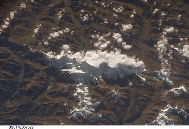
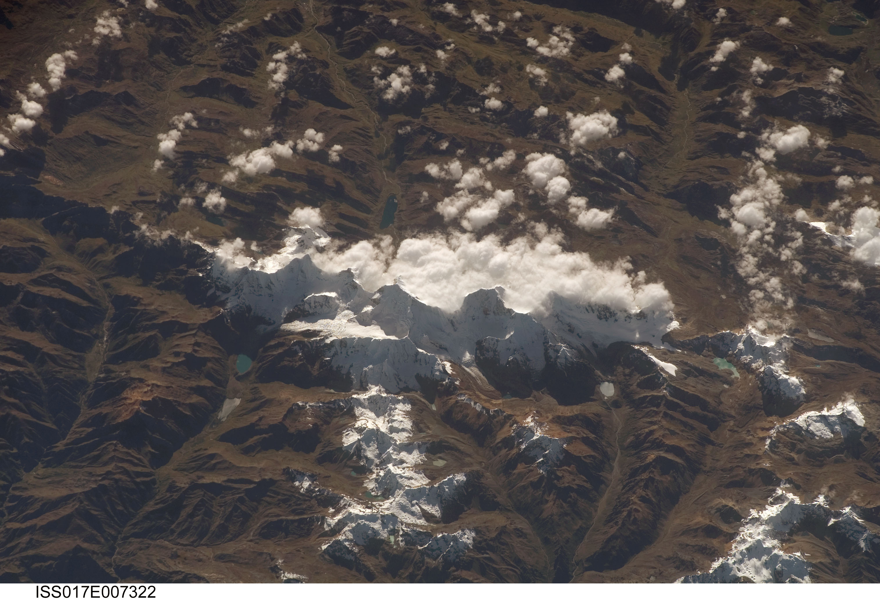
Image Caption: Cordillera Huayhuash, Peruvian Andes
This astronaut photograph was taken looking east as the International Space Station was flying about 100 kilometers (about 62 miles) off the Peruvian coast and shows Cordillera Huayhuash (pronounced "Why-wash"). Clouds are banked up on the east side, snow covers all higher slopes and mountain peaks, and glaciers occupy lower slopes. This prominent but short mountain range (25 kilometers in length) boasts twenty peaks of remarkable steepness and ridge sharpness. Although only 100 kilometers from the coastline, six of the peaks reach above 6,000 meters (more than 19,500 feet); the highest is Nevado Yerupaja, Peru's second highest peak, variously estimated as 6,617 and 6,635 meters high.
Widely considered the most spectacular peak in South America, Yerupaja is so steep that it has seldom been climbed. The best climbing approach is from the southwest, the face seen in this view. Yerupaja is locally known as El Carnicero ("The Butcher") because of its blade-like ridges, typical of mountains that have been heavily eroded by glacial ice. Other features created by the erosive effect of flowing ice are small glacial lakes, which often vary in color due to different amounts of fine mud being fed into them by meltwater from under the glaciers. During the ice ages, the glaciers advanced many kilometers outward from the cordillera, occupying all the surrounding valley floors (all of which lie above 3,000 meters), producing U-shape valleys.
