STS094-743-7
| NASA Photo ID | STS094-743-7 |
| Focal Length | 250mm |
| Date taken | 1997.07.03 |
| Time taken | 13:36:58 GMT |


Cloud masks available for this image:
Spacecraft nadir point: 21.1° N, 73.6° W
Photo center point: 20.5° N, 76.0° W
Photo center point by machine learning:
Photo center point: 20.5° N, 76.0° W
Photo center point by machine learning:
Nadir to Photo Center: West
Spacecraft Altitude: 160 nautical miles (296km)
Country or Geographic Name: | CUBA |
Features: | BAY OF NIPE |
| Features Found Using Machine Learning: | |
Cloud Cover Percentage: | 5 (1-10)% |
Sun Elevation Angle: | 43° |
Sun Azimuth: | 78° |
Camera: | Hasselblad |
Focal Length: | 250mm |
Camera Tilt: | 43 degrees |
Format: | 5069: Kodak Elite 100S, E6 Reversal, Replaces Lumiere, Warmer in tone vs. Lumiere |
Film Exposure: | Normal |
| Additional Information | |
| Width | Height | Annotated | Cropped | Purpose | Links |
|---|---|---|---|---|---|
| 4096 pixels | 4096 pixels | No | No | Earth From Space collection | Download Image |
| 640 pixels | 640 pixels | No | No | Earth From Space collection | Download Image |
| 517 pixels | 505 pixels | No | No | Download Image |
Download Packaged File
Download a Google Earth KML for this Image
View photo footprint information
Download a GeoTIFF for this photo
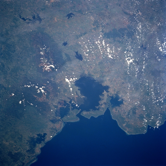
Image Caption: STS094-743-007 Nipe Bay, Cuba July 1997
Nipe Bay (large, dark embayment) is located near the eastern end of the island and along the northeast coast of Cuba. According to published environmental reports this bay has a recent history of contamination from sewage and industrial waste runoff. Faint discolorations within the bay indicate that runoff seems to be entering the water from several different sources. The lighter terrain that is partially obscured by scattered clouds within the darker landscape south to southeast of the bay shows an extensive area of mining operations. This mining activity includes a wide range of alloy minerals--specifically manganese and nickel. The darker features are the western end of a forested mountain range, known as the Sierra de Micaro that is found along the extreme northeast coast of Cuba. Several sizable reservoirs (dark, irregular-shaped features) can be identified within the extensive agricultural lands west of the mountains.
Nipe Bay (large, dark embayment) is located near the eastern end of the island and along the northeast coast of Cuba. According to published environmental reports this bay has a recent history of contamination from sewage and industrial waste runoff. Faint discolorations within the bay indicate that runoff seems to be entering the water from several different sources. The lighter terrain that is partially obscured by scattered clouds within the darker landscape south to southeast of the bay shows an extensive area of mining operations. This mining activity includes a wide range of alloy minerals--specifically manganese and nickel. The darker features are the western end of a forested mountain range, known as the Sierra de Micaro that is found along the extreme northeast coast of Cuba. Several sizable reservoirs (dark, irregular-shaped features) can be identified within the extensive agricultural lands west of the mountains.
