STS073-745-48

| NASA Photo ID | STS073-745-48 |
| Focal Length | 250mm |
| Date taken | 1995.11.02 |
| Time taken | 19:24:43 GMT |
Resolutions offered for this image:
3913 x 3936 pixels 636 x 639 pixels 5700 x 5900 pixels 500 x 518 pixels 640 x 480 pixels
3913 x 3936 pixels 636 x 639 pixels 5700 x 5900 pixels 500 x 518 pixels 640 x 480 pixels


Cloud masks available for this image:
Spacecraft nadir point: 21.9° N, 155.7° W
Photo center point: 21.5° N, 158.0° W
Photo center point by machine learning:
Photo center point: 21.5° N, 158.0° W
Photo center point by machine learning:
Nadir to Photo Center: West
Spacecraft Altitude: 142 nautical miles (263km)
Camera: | Hasselblad |
Focal Length: | 250mm |
Camera Tilt: | 45 degrees |
Format: | 2443: Kodak Aerochrome 2443, color IR, thin base, EA-5 process thru June 1999, E-6 process afterward |
Film Exposure: | Normal |
| Additional Information | |
| Width | Height | Annotated | Cropped | Purpose | Links |
|---|---|---|---|---|---|
| 3913 pixels | 3936 pixels | No | No | Earth From Space collection | Download Image |
| 636 pixels | 639 pixels | No | No | Earth From Space collection | Download Image |
| 5700 pixels | 5900 pixels | No | No | Download Image | |
| 500 pixels | 518 pixels | No | No | Download Image | |
| 640 pixels | 480 pixels | No | No | Download Image |
Download Packaged File
Download a Google Earth KML for this Image
View photo footprint information
Download a GeoTIFF for this photo
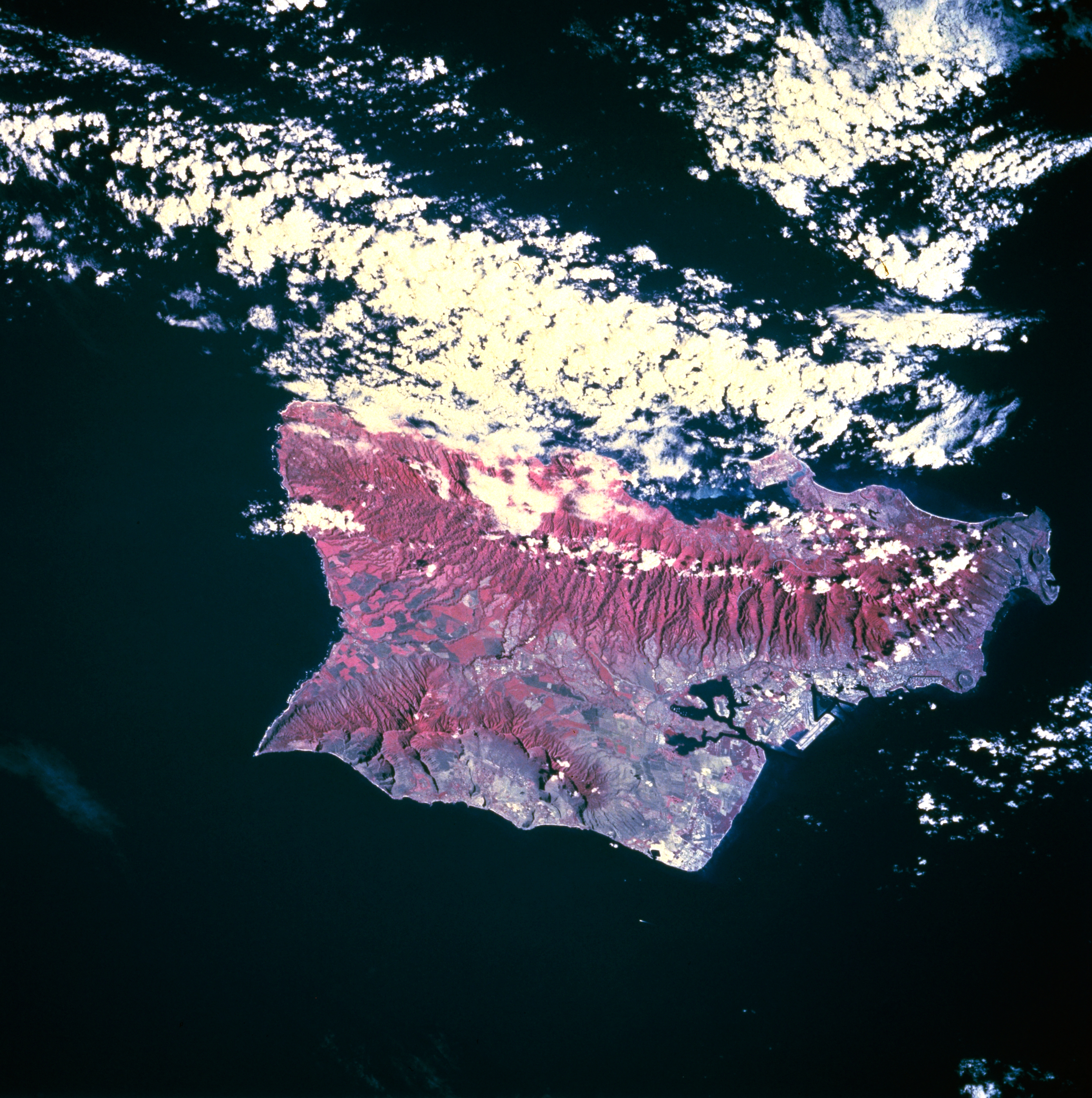
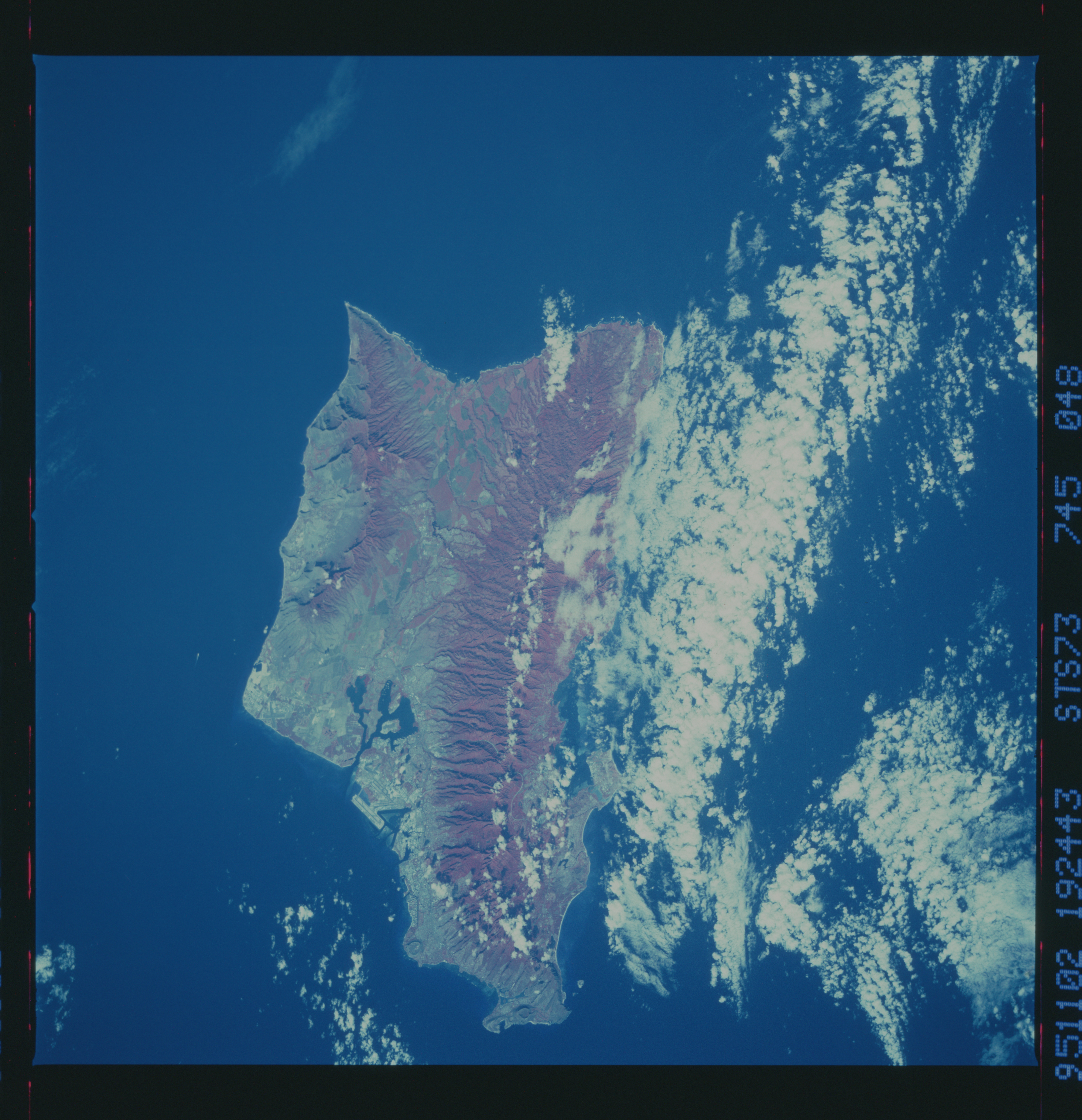
Image Caption: STS073-745-048 Oahu, Hawaii, U.S.A. October 1995
This infrared photograph provides information about the severity of erosion on the slopes of the island's two mountain ranges. The infrared film highlights the ruggedness of both the larger Koolau Range [3150 feet (960 meters)] on the northeast and the Waianae Range [4025 feet (1227 meters)] near the southwest coast. The infrared film also helps delineate the land-water boundaries, especially around Pearl Harbor. Easily discernible is Honolulu International Airport along the south-central coast. Large green cultivated field patterns near the northwest end of the island (shown in red) indicate healthy crops are growing on large plantations.
This infrared photograph provides information about the severity of erosion on the slopes of the island's two mountain ranges. The infrared film highlights the ruggedness of both the larger Koolau Range [3150 feet (960 meters)] on the northeast and the Waianae Range [4025 feet (1227 meters)] near the southwest coast. The infrared film also helps delineate the land-water boundaries, especially around Pearl Harbor. Easily discernible is Honolulu International Airport along the south-central coast. Large green cultivated field patterns near the northwest end of the island (shown in red) indicate healthy crops are growing on large plantations.
