STS032-101-27
| NASA Photo ID | STS032-101-27 |
| Focal Length | 100mm |
| Date taken | 1990.01.14 |
| Time taken | 06:38:40 GMT |
Resolutions offered for this image:
5152 x 5152 pixels 640 x 640 pixels 5700 x 5900 pixels 500 x 518 pixels 640 x 480 pixels
5152 x 5152 pixels 640 x 640 pixels 5700 x 5900 pixels 500 x 518 pixels 640 x 480 pixels


Cloud masks available for this image:
Spacecraft nadir point: 14.7° N, 44.2° E
Photo center point: 10.5° N, 41.5° E
Photo center point by machine learning:
Photo center point: 10.5° N, 41.5° E
Photo center point by machine learning:
Nadir to Photo Center: Southwest
Spacecraft Altitude: 177 nautical miles (328km)
Country or Geographic Name: | ETHIOPIA |
Features: | AFAR DEPRESSION |
| Features Found Using Machine Learning: | |
Cloud Cover Percentage: | 30 (26-50)% |
Sun Elevation Angle: | 37° |
Sun Azimuth: | 132° |
Camera: | Hasselblad |
Focal Length: | 100mm |
Camera Tilt: | High Oblique |
Format: | 5036: Kodak, natural color positive, Ektachrome 5036,200 Professional, ASA 200, stand |
Film Exposure: | Normal |
| Additional Information | |
| Width | Height | Annotated | Cropped | Purpose | Links |
|---|---|---|---|---|---|
| 5152 pixels | 5152 pixels | No | No | Earth From Space collection | Download Image |
| 640 pixels | 640 pixels | No | No | Earth From Space collection | Download Image |
| 5700 pixels | 5900 pixels | No | No | Download Image | |
| 500 pixels | 518 pixels | No | No | Download Image | |
| 640 pixels | 480 pixels | No | No | Download Image |
Download Packaged File
Download a Google Earth KML for this Image
View photo footprint information
Download a GeoTIFF for this photo
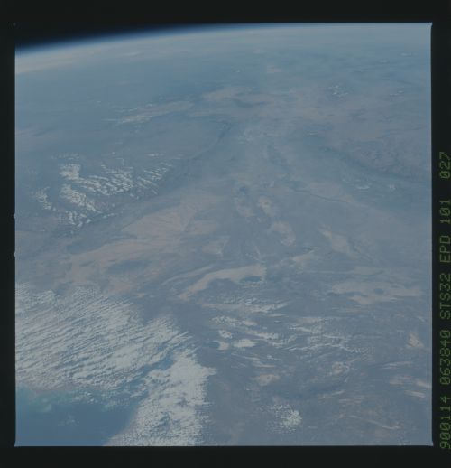
Image Caption: STS032-101-027 Denakil Desert and Denakil Depression, Ethiopia January 1990
This southwest-looking, high-oblique photograph shows the throat of the "Y" that has been formed in northern Ethiopia as the sides of the Great African Rift Valley move farther apart. The east-west-trending Ahmar Mountains form the Rift Valley's southern boundary, and a significant north-south-trending escarpment (near the western edge of photograph) creates an elevation change of approximately 5000 feet (1525 meters). The top ends of the "Y" extend into Djibouti to the east and Eritrea to the north. The desert area between the two arms of the "Y" is the Denakil Desert, and the lowest part of this desert is the Denakil Depression. The desert is an area of scorching heat and active volcanoes that belch smoke, sulfurous fumes, and hot springs that often present strangely colored waters because of the mineral content. The Awash River, whose waters evaporate and never reach the sea, is the only relief in the harsh southwest part of the region. Djibouti, most of which is obscured by cloud cover, and small Lake Assal with its whitish salt plain northwest of the lake, are visible in the southeast portion of the photograph. Blue Lake Assal, reportedly the saltiest body of water in the world, is also the lowest point in Africa at 510 feet (155 meters) below sea level.
This southwest-looking, high-oblique photograph shows the throat of the "Y" that has been formed in northern Ethiopia as the sides of the Great African Rift Valley move farther apart. The east-west-trending Ahmar Mountains form the Rift Valley's southern boundary, and a significant north-south-trending escarpment (near the western edge of photograph) creates an elevation change of approximately 5000 feet (1525 meters). The top ends of the "Y" extend into Djibouti to the east and Eritrea to the north. The desert area between the two arms of the "Y" is the Denakil Desert, and the lowest part of this desert is the Denakil Depression. The desert is an area of scorching heat and active volcanoes that belch smoke, sulfurous fumes, and hot springs that often present strangely colored waters because of the mineral content. The Awash River, whose waters evaporate and never reach the sea, is the only relief in the harsh southwest part of the region. Djibouti, most of which is obscured by cloud cover, and small Lake Assal with its whitish salt plain northwest of the lake, are visible in the southeast portion of the photograph. Blue Lake Assal, reportedly the saltiest body of water in the world, is also the lowest point in Africa at 510 feet (155 meters) below sea level.
