ISS014-E-12652

| NASA Photo ID | ISS014-E-12652 |
| Focal Length | 800mm |
| Date taken | 2007.01.21 |
| Time taken | 14:40:06 GMT |
Resolutions offered for this image:
1000 x 595 pixels 540 x 321 pixels 540 x 334 pixels 3032 x 2064 pixels 639 x 435 pixels
1000 x 595 pixels 540 x 321 pixels 540 x 334 pixels 3032 x 2064 pixels 639 x 435 pixels


Cloud masks available for this image:
Spacecraft nadir point: 44.5° N, 70.0° W
Photo center point: 45.5° N, 73.6° W
Photo center point by machine learning:
Photo center point: 45.5° N, 73.6° W
Photo center point by machine learning:
Nadir to Photo Center: West
Spacecraft Altitude: 171 nautical miles (317km)
Country or Geographic Name: | CANADA-Q |
Features: | MONTREAL, SNOW, MONT ROYAL, R. |
| Features Found Using Machine Learning: | |
Cloud Cover Percentage: | 10 (1-10)% |
Sun Elevation Angle: | 19° |
Sun Azimuth: | 147° |
Camera: | Kodak DCS760c Electronic Still Camera |
Focal Length: | 800mm |
Camera Tilt: | 53 degrees |
Format: | 3060E: 3060 x 2036 pixel CCD, RGBG array |
Film Exposure: | |
| Additional Information | |
| Width | Height | Annotated | Cropped | Purpose | Links |
|---|---|---|---|---|---|
| 1000 pixels | 595 pixels | No | Yes | Earth From Space collection | Download Image |
| 540 pixels | 321 pixels | Yes | Yes | Earth From Space collection | Download Image |
| 540 pixels | 334 pixels | Yes | Yes | NASA's Earth Observatory web site | Download Image |
| 3032 pixels | 2064 pixels | No | No | Download Image | |
| 639 pixels | 435 pixels | No | No | Download Image |
Download Packaged File
Download a Google Earth KML for this Image
View photo footprint information
Download a GeoTIFF for this photo
Image Caption: Montreal
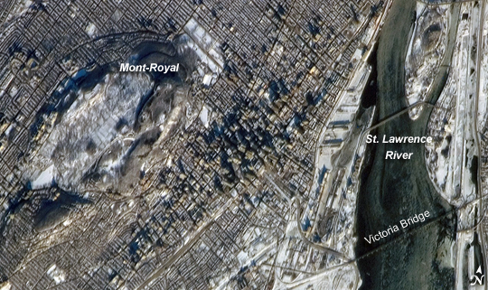
The largest city in the Canadian province of Quebec and the largest inland port in the world, Montreal takes its name from a distinctive landscape feature at the center of the city. Mont-Royal ("royal mountain" in French) rises to an elevation of 233 meters (about 764 feet) at Colline de la Croix peak. The mountain is sometimes identified in guidebooks as an extinct volcano, but the types of igneous rock found at Mont-Royal suggest the mountain is more likely to be the remnants of magma chambers that once fed surface volcanoes than a surface volcano itself. The Parc du Mont-Royal--one of the city's largest forested greenspaces--is located on the lower slopes of the mountain (appearing as gray-green regions in the image), while the Notre-Dame-des-Neiges Cemetery occupies most of the upper snow-covered area of Mont-Royal visible in the image.
This astronaut photograph was taken while the International Space Station (ISS) was located approximately 306 kilometers (about 190 miles) to the southeast over Mount Vernon, Maine. The astronaut was looking northwest to capture the morning sunlight on a snow-dusted Montreal. Individual skyscrapers of the downtown area are clearly visible, highlighted by the long shadows they cast in the light of the rising sun. The high-rise profile of the downtown area contrasts sharply with a distinctive grid pattern of residential, commercial, and institutional city blocks to the north, south, and west, which are outlined by the snow cover. The combination of oblique viewing angle and sun position also allow for the capture of sunglint--light reflected directly back to the camera on the ISS--on the St. Lawrence River at image right. The glint reveals ice on the river; several large chunks are visible to the north of the Victoria Bridge (image lower right). The image is detailed enough to capture individual support pylons on the bridge.
