Geographic Region: MEXICO
Feature: GUADALAJARA
|
Geographic Region: MEXICO Feature: GUADALAJARA |
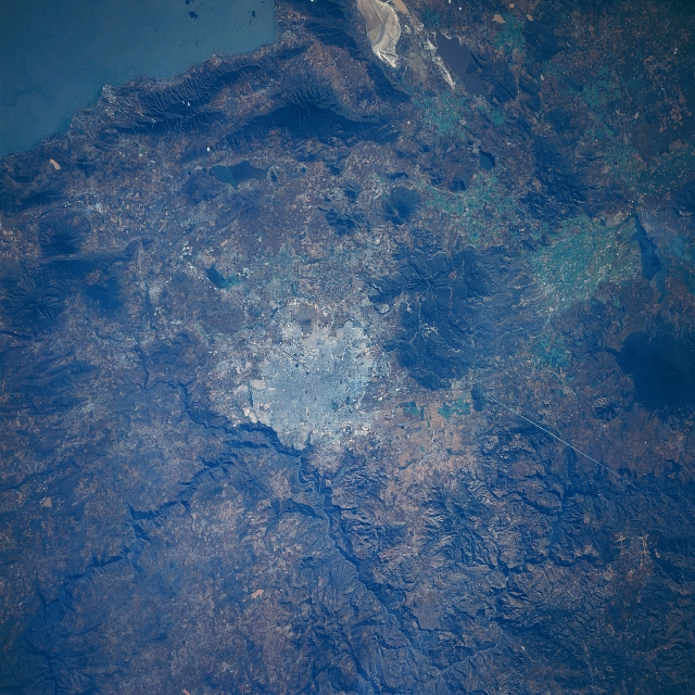 |
| STS61B-40-0064 Guadalajara, Mexico November 1985 Sometimes referred to as the 'Silicon Valley' of Mexico, the second largest city in Mexico, Guadalajara, can be seen (center of the image) in this south-looking view. Located on a high plain (over 5000 feet-1525 meters) and surrounded by mountains, Guadalajara is the center of a rich agricultural and industrial area. The city is an important mining center and produces chemicals and textiles. Tourism is also an important industry as the city retains much of its Spanish colonial and historic heritage. With its mild, clear, and dry climate, Guadalajara is also a popular health resort. Located 30 miles (48 km) south-southeast of Guadalajara is Lake Chapala (upper left of the image), the largest natural lake in Mexico. Recently, the lake has been plagued by runoff from chemical plants and oil refineries located on its shores as well as an influx of fertilizers and pesticides from the surrounding agricultural lands. |
| Images: | All Available Images Low-Resolution 397k |
|
| Mission: | STS61B |
|
| Roll - Frame: | 40 - 64 |
|
| Geographical Name: | MEXICO |
|
| Features: | GUADALAJARA |
|
| Center Lat x Lon: | 20.5N x 103.5W |
|
| Film Exposure: | N | N=Normal exposure, U=Under exposed, O=Over exposed, F=out of Focus |
| Percentage of Cloud Cover-CLDP: | 5 |
|
| Camera:: | HB |
|
| Camera Tilt: | 26 | LO=Low Oblique, HO=High Oblique, NV=Near Vertical |
| Camera Focal Length: | 250 |
|
| Nadir to Photo Center Direction: | W | The direction from the nadir to the center point, N=North, S=South, E=East, W=West |
| Stereo?: | N | Y=Yes there is an adjacent picture of the same area, N=No there isn't |
| Orbit Number: | 46 |
|
| Date: | 19851129 | YYYYMMDD |
| Time: | 210824 | GMT HHMMSS |
| Nadir Lat: | 20.1N |
Latitude of suborbital point of spacecraft |
| Nadir Lon: | 101.9W |
Longitude of suborbital point of spacecraft |
| Sun Azimuth: | 223 | Clockwise angle in degrees from north to the sun measured at the nadir point |
| Space Craft Altitude: | 199 | nautical miles |
| Sun Elevation: | 34 | Angle in degrees between the horizon and the sun, measured at the nadir point |
| Land Views: | UPLAND, MOUNTAIN |
|
| Water Views: | LAKE |
|
| Atmosphere Views: | |
|
| Man Made Views: | URBAN AREA |
|
| City Views: | GUADALAJARA |
|
Photo is not associated with any sequences | ||
| NASA Home Page |
JSC Home Page |
JSC Digital Image Collection |
Earth Science & Remote Sensing |
|
This service is provided by the International Space Station program and the JSC Earth Science & Remote Sensing Unit, ARES Division, Exploration Integration Science Directorate.

|