
Geographic Region: USA-OREGON
Feature: CASCADE RANGE
|
Geographic Region: USA-OREGON Feature: CASCADE RANGE |
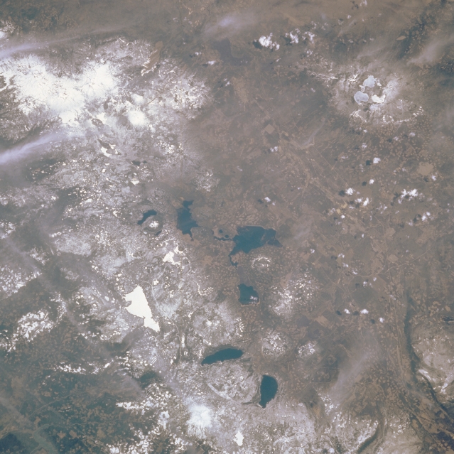 |
| STS51B-038-0089 Central Cascades and Newberry Crater, Oregon, U.S.A. May 1985 This northeast-looking, low-oblique photograph includes the central Oregon Cascade Range from the Three Sisters and Mount Bachelor Volcanoes near the top left to Diamond Peak Volcano and Crescent Lake near the bottom center. Newberry Crater National Park, one of the newest parks in the United States, is visible at the upper right of the photograph. Newberry, having lost its summit to a gigantic explosion nearly 7000 years ago, is much like Crater Lake to the southwest (not visible in this image). Hot springs in the two ice-covered lakes inside Newberry's caldera are the only surface signs of continuing volcanic activity. Geothermal exploration has revealed that temperatures exceed 500 degrees F only 3000 feet (915 meters) beneath the floor of the caldera; these are the highest temperatures recorded at a dormant Cascade Range volcano. Easily discernible are bright white (frozen) Waldo Lake near the left center of the photograph and numerous dark blue lakes. |
| Images: | All Available Images Low-Resolution 335k |
|
| Mission: | STS51B |
|
| Roll - Frame: | 38 - 89 |
|
| Geographical Name: | USA-OREGON |
|
| Features: | CASCADE RANGE |
|
| Center Lat x Lon: | 43.5N x 122W |
|
| Film Exposure: | N | N=Normal exposure, U=Under exposed, O=Over exposed, F=out of Focus |
| Percentage of Cloud Cover-CLDP: | 10 |
|
| Camera:: | HB |
|
| Camera Tilt: | NV | LO=Low Oblique, HO=High Oblique, NV=Near Vertical |
| Camera Focal Length: | 250 |
|
| Nadir to Photo Center Direction: | The direction from the nadir to the center point, N=North, S=South, E=East, W=West |
|
| Stereo?: | Y | Y=Yes there is an adjacent picture of the same area, N=No there isn't |
| Orbit Number: | 19 |
|
| Date: | 1985____ | YYYYMMDD |
| Time: | GMT HHMMSS |
|
| Nadir Lat: | N |
Latitude of suborbital point of spacecraft |
| Nadir Lon: | E |
Longitude of suborbital point of spacecraft |
| Sun Azimuth: | Clockwise angle in degrees from north to the sun measured at the nadir point |
|
| Space Craft Altitude: | nautical miles |
|
| Sun Elevation: | Angle in degrees between the horizon and the sun, measured at the nadir point |
|
| Land Views: | MOUNTAIN, FAULT |
|
| Water Views: | PLAYA |
|
| Atmosphere Views: | |
|
| Man Made Views: | |
|
| City Views: | |
|
Photo is not associated with any sequences | ||
| NASA Home Page |
JSC Home Page |
JSC Digital Image Collection |
Earth Science & Remote Sensing |
|
This service is provided by the International Space Station program and the JSC Earth Science & Remote Sensing Unit, ARES Division, Exploration Integration Science Directorate.

|