
Geographic Region: USA-NEW YORK
Feature: LAKE CHAMPLAIN
|
Geographic Region: USA-NEW YORK Feature: LAKE CHAMPLAIN |
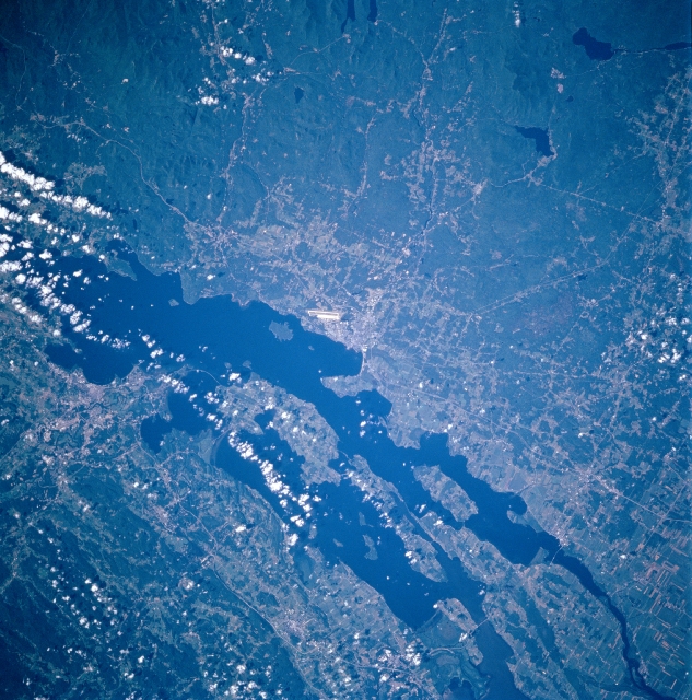 |
| STS085-713-031 Lake Champlain, New York August 1997 Lying in a broad valley between the Adirondacks in New York (lower half of image), and the Green Mountains of Vermont (upper right of the image), the northern half of Lake Champlain can be seen in this north-northeast-looking low-oblique view. With a surface area of 435 square miles (1127 sq. km), Lake Champlain is 120 miles (193 km) long and 12 miles (19 km) at its widest point, and is the sixth largest lake in the United States. The greatest depth of the lake is 400 feet (122 meters), but the average depth is 64 feet (20 meters). Lake Champlain has nearly 587 miles (945 km) of shoreline. Over 70 islands, most in the northern half, are situated in the lake. The lake is a popular recreation region year around. Initial discussions are underway between scientists and government personnel to make Lake Champlain the sixth Great Lake adding to Lakes Superior, Michigan, Huron, Erie, and Ontario. Visible near the center of the image and on the western shore of Lake Champlain is the major runway at Plattsburgh Air Force Base, a Strategic Air Command installation. Plattsburgh, New York is a trade and distribution point with plants that make paper and plastics. Tourism is also a major industry. The city of Burlington, Vermont is discernible near the right center of the image situated on the eastern shore of Lake Champlain. Burlington is the largest city in Vermont and is a major industrial center. Products include missile and ordnance parts, data-processing machinery, textiles, and wood and steel products. |
| Images: | All Available Images Low-Resolution 397k |
|
| Mission: | STS085 |
|
| Roll - Frame: | 713 - 31 |
|
| Geographical Name: | USA-NEW YORK |
|
| Features: | LAKE CHAMPLAIN |
|
| Center Lat x Lon: | 44.5N x 73W |
|
| Film Exposure: | N | N=Normal exposure, U=Under exposed, O=Over exposed, F=out of Focus |
| Percentage of Cloud Cover-CLDP: | 15 |
|
| Camera:: | HB |
|
| Camera Tilt: | 33 | LO=Low Oblique, HO=High Oblique, NV=Near Vertical |
| Camera Focal Length: | 100 |
|
| Nadir to Photo Center Direction: | S | The direction from the nadir to the center point, N=North, S=South, E=East, W=West |
| Stereo?: | Y | Y=Yes there is an adjacent picture of the same area, N=No there isn't |
| Orbit Number: | 80 |
|
| Date: | 19970812 | YYYYMMDD |
| Time: | 135049 | GMT HHMMSS |
| Nadir Lat: | 46.2N |
Latitude of suborbital point of spacecraft |
| Nadir Lon: | 72.9W |
Longitude of suborbital point of spacecraft |
| Sun Azimuth: | 113 | Clockwise angle in degrees from north to the sun measured at the nadir point |
| Space Craft Altitude: | 155 | nautical miles |
| Sun Elevation: | 40 | Angle in degrees between the horizon and the sun, measured at the nadir point |
| Land Views: | MOUNTAIN, FOREST |
|
| Water Views: | LAKE |
|
| Atmosphere Views: | |
|
| Man Made Views: | URBAN AREA, AIRPORT |
|
| City Views: | |
|
Photo is not associated with any sequences | ||
| NASA Home Page |
JSC Home Page |
JSC Digital Image Collection |
Earth Science & Remote Sensing |
|
This service is provided by the International Space Station program and the JSC Earth Science & Remote Sensing Unit, ARES Division, Exploration Integration Science Directorate.

|