Geographic Region: NORTH KOREA
Feature: YALU RIVER, MOUNTAINS
|
Geographic Region: NORTH KOREA Feature: YALU RIVER, MOUNTAINS |
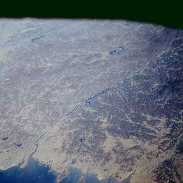 |
| STS058-084-029 Yalu River, China and North Korea October 1993 This north-looking, low-oblique photograph shows the Yalu River that forms the border between China and North Korea. The Yalu, more than 500 miles (805 kilometers) long, originates in the Changpai Mountains of China and flows southwest into Korea Bay. The river is navigable for larger vessels for almost 15 miles (24 kilometers) in the lower reaches, but only for smaller craft in other sections. Important cities at its mouth are Dandong (Chinese) and Sinuiju (Korean), both of which have sawmills and other wood-processing industries that use the timber floated downstream. The Yalu River has a hydroelectric power potential estimated at 1.5 million kilowatts. The Shuifeng Dam on the Yalu (near center of photograph) above the city of Sinuiju is one of the largest dams in Asia. Manchuria's need for hydroelectric power in the early 1950s might have been a reason for Chinese Communist troops entering the Korean War when United Nations troops reached the Yalu. Construction of electric power facilities in Manchuria since the late 1950s has lessened the importance of the Yalu's power plants to China. |
| Images: | All Available Images Low-Resolution 137k |
|
| Mission: | STS058 |
|
| Roll - Frame: | 84 - 29 |
|
| Geographical Name: | NORTH KOREA |
|
| Features: | YALU RIVER, MOUNTAINS |
|
| Center Lat x Lon: | 40.5N x 125.5E |
|
| Film Exposure: | N | N=Normal exposure, U=Under exposed, O=Over exposed, F=out of Focus |
| Percentage of Cloud Cover-CLDP: | 0 |
|
| Camera:: | HB |
|
| Camera Tilt: | 46 | LO=Low Oblique, HO=High Oblique, NV=Near Vertical |
| Camera Focal Length: | 100 |
|
| Nadir to Photo Center Direction: | N | The direction from the nadir to the center point, N=North, S=South, E=East, W=West |
| Stereo?: | Y | Y=Yes there is an adjacent picture of the same area, N=No there isn't |
| Orbit Number: | 120 |
|
| Date: | 19931026 | YYYYMMDD |
| Time: | 014313 | GMT HHMMSS |
| Nadir Lat: | 38.0N |
Latitude of suborbital point of spacecraft |
| Nadir Lon: | 125.2E |
Longitude of suborbital point of spacecraft |
| Sun Azimuth: | 150 | Clockwise angle in degrees from north to the sun measured at the nadir point |
| Space Craft Altitude: | 147 | nautical miles |
| Sun Elevation: | 35 | Angle in degrees between the horizon and the sun, measured at the nadir point |
| Land Views: | MOUNTAIN, COAST, FAULT |
|
| Water Views: | RIVER, RESERVOIR, BAY |
|
| Atmosphere Views: | |
|
| Man Made Views: | URBAN AREA, DAM |
|
| City Views: | |
|
Photo is not associated with any sequences | ||
| NASA Home Page |
JSC Home Page |
JSC Digital Image Collection |
Earth Science & Remote Sensing |
|
This service is provided by the International Space Station program and the JSC Earth Science & Remote Sensing Unit, ARES Division, Exploration Integration Science Directorate.

|