Geographic Region: BOLIVIA
Feature: L. POOPO,S. UYUNI,S. COIPAS
|
Geographic Region: BOLIVIA Feature: L. POOPO,S. UYUNI,S. COIPAS |
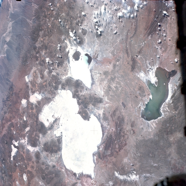 |
| SL3-115-1911 Altiplano, Bolivia August 1973 Areas of water in a predominately arid landscape appear in this near-vertical photograph of the southwest Bolivian altiplano. The western part of the photograph shows the extremely arid, nonvegetated foothills of the Andes Mountains. These foothills, an eastward extension of the Atacama Desert of northern Chile, are proclaimed by many climatologists and meteorologists to be the driest desert on Earth. The whiteness of the highly reflective dry lakebeds (salars) is created by evaporation whereby salts are left on the surface of the ground. The largest and second largest lakebeds are Salar de Uyuni and Salar de Coiposa, respectively. Numerous smaller salars are scattered throughout the photograph, and there is some evidence of salt flats around Lake Poopó to the east. The northeast corner of Salar de Coiposa contains a small pool of water. When water drainage occurs in this region, Salar de Coiposa and Lake Poopó can be supplied from the northern part of the basin--from as far away as Lake Titicaca; however, Salar de Uyuni is fed mainly from snowmelt from the south and southeast. The Cordillera Occidental, the westernmost axis of the Andes Mountains, has hundreds of volcanic features. (See photograph STS-026-040-064 for a detailed description of a smaller area of the altiplano.) |
| Images: | All Available Images Low-Resolution 340k |
|
| Mission: | SL3 |
|
| Roll - Frame: | 115 - 1911 |
|
| Geographical Name: | BOLIVIA |
|
| Features: | L. POOPO,S. UYUNI,S. COIPAS |
|
| Center Lat x Lon: | 19.5S x 67.5W |
|
| Film Exposure: | N | N=Normal exposure, U=Under exposed, O=Over exposed, F=out of Focus |
| Percentage of Cloud Cover-CLDP: | 10 |
|
| Camera:: | HB |
|
| Camera Tilt: | LO | LO=Low Oblique, HO=High Oblique, NV=Near Vertical |
| Camera Focal Length: | 100 |
|
| Nadir to Photo Center Direction: | The direction from the nadir to the center point, N=North, S=South, E=East, W=West |
|
| Stereo?: | N | Y=Yes there is an adjacent picture of the same area, N=No there isn't |
| Orbit Number: | |
|
| Date: | 1973____ | YYYYMMDD |
| Time: | GMT HHMMSS |
|
| Nadir Lat: | N |
Latitude of suborbital point of spacecraft |
| Nadir Lon: | E |
Longitude of suborbital point of spacecraft |
| Sun Azimuth: | Clockwise angle in degrees from north to the sun measured at the nadir point |
|
| Space Craft Altitude: | nautical miles |
|
| Sun Elevation: | Angle in degrees between the horizon and the sun, measured at the nadir point |
|
| Land Views: | VOLCANO, MOUNTAIN, SALAR, PLATEAU |
|
| Water Views: | LAKE, SEDIMENT |
|
| Atmosphere Views: | |
|
| Man Made Views: | |
|
| City Views: | |
|
Associated Photos in Sequence:  Photo #: STS057-99-65 Photo #: STS057-99-65Description: PERU/BOLIVIA-1993; L. TITICACA, L. POOPO REGION-SYNOPTIC VIEW Sequence ID: 6A  Photo #: SL3-115-1911 ** Currently displayed photo ** Photo #: SL3-115-1911 ** Currently displayed photo ** Description: BOLIVIA, LAKE POOPO-1973; LAKE LEVEL Sequence ID: 6B  Photo #: STS51J-144-23 Photo #: STS51J-144-23Description: BOLIVIA, LAKE POOPO-1985; LAKE LEVEL Sequence ID: 6C  Photo #: STS026-40-64 Photo #: STS026-40-64Description: BOLIVIA, LAKE POOPO, LAKE COIPASA-1988; LAKE POOPO LAKE LEVEL Sequence ID: 6D  Photo #: STS032-88-69 Photo #: STS032-88-69Description: BOLIVIA, LAKE POOPO-1990; LAKE LEVEL Sequence ID: 6E  Photo #: STS048-72-49 Photo #: STS048-72-49Description: BOLIVIA, LAKE POOPO-1991; LAKE LEVEL CHANGES Sequence ID: 6F  Photo #: STS064-91-22 Photo #: STS064-91-22Description: BOLIVIA, LAKE POOPO-1994; DECREASING LAKE LEVEL Sequence ID: 6G  Photo #: STS073-735-47 Photo #: STS073-735-47Description: BOLIVIA, LAKE POOPO-1995; LAKE IS DRY Sequence ID: 6H | ||
| NASA Home Page |
JSC Home Page |
JSC Digital Image Collection |
Earth Science & Remote Sensing |
|
This service is provided by the International Space Station program and the JSC Earth Science & Remote Sensing Unit, ARES Division, Exploration Integration Science Directorate.

|