Geographic Region: ITALY
Feature: APPENNINES, NAPOLI
|
Geographic Region: ITALY Feature: APPENNINES, NAPOLI |
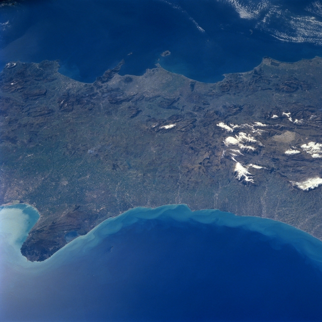 |
| NM23-707-418 Gargano Peninsula, Italy Winter/Spring 1997 The Appennine Mountains, trending northwest to southeast along the central spine of Italy, become lower in elevation near the southern end of mainland Italy, specifically the mountainous area east of Naples. The Naples urban area can be located by identifying the Gulf of Naples (two islands--Capri and Ischia border the south and north entrance) in the upper, center section of the picture. The small, dark, roughly circular feature, Mt. Vesuvius, is also discernible near the Gulf of Naples coastline. Snow capped mountains (numerous white features--right middle) that are higher than 7000 feet (2134 meters) above sea level can be identified along the right (middle) margin of the image. In the foreground (left) the limestone peninsula of Gargano extends into the Adriatic Sea. This feature, known as the "spur" of Italy, includes limestone terraces; caves; precipitous cliffs; white, sandy beaches; and forests. Lake Varano, one of the coastal lakes is visible along the north coast of the Gargano Peninsula. Numerous swift-flowing, short rivers drain the narrow strip of plains along the east coast of Italy. |
| Images: | All Available Images Low-Resolution 298k |
|
| Mission: | NM23 |
|
| Roll - Frame: | 707 - 418 |
|
| Geographical Name: | ITALY |
|
| Features: | APPENNINES, NAPOLI |
|
| Center Lat x Lon: | 41.0N x 14.5E |
|
| Film Exposure: | N | N=Normal exposure, U=Under exposed, O=Over exposed, F=out of Focus |
| Percentage of Cloud Cover-CLDP: | 5 |
|
| Camera:: | HB |
|
| Camera Tilt: | LO | LO=Low Oblique, HO=High Oblique, NV=Near Vertical |
| Camera Focal Length: | 100 |
|
| Nadir to Photo Center Direction: | E | The direction from the nadir to the center point, N=North, S=South, E=East, W=West |
| Stereo?: | Y | Y=Yes there is an adjacent picture of the same area, N=No there isn't |
| Orbit Number: | |
|
| Date: | 19970312 | YYYYMMDD |
| Time: | GMT HHMMSS |
|
| Nadir Lat: | N |
Latitude of suborbital point of spacecraft |
| Nadir Lon: | E |
Longitude of suborbital point of spacecraft |
| Sun Azimuth: | Clockwise angle in degrees from north to the sun measured at the nadir point |
|
| Space Craft Altitude: | nautical miles |
|
| Sun Elevation: | Angle in degrees between the horizon and the sun, measured at the nadir point |
|
| Land Views: | PENINSULA, MOUNTAIN |
|
| Water Views: | SEA |
|
| Atmosphere Views: | |
|
| Man Made Views: | |
|
| City Views: | |
|
Photo is not associated with any sequences | ||
| NASA Home Page |
JSC Home Page |
JSC Digital Image Collection |
Earth Science & Remote Sensing |
|
This service is provided by the International Space Station program and the JSC Earth Science & Remote Sensing Unit, ARES Division, Exploration Integration Science Directorate.

|