Geographic Region: NICARAGUA
Feature: APOYEQUE VOLCANO,CHILTEPE PENINSULA,XILOA LAKE,LAKE MANAGUA
|
Geographic Region: NICARAGUA Feature: APOYEQUE VOLCANO,CHILTEPE PENINSULA,XILOA LAKE,LAKE MANAGUA |
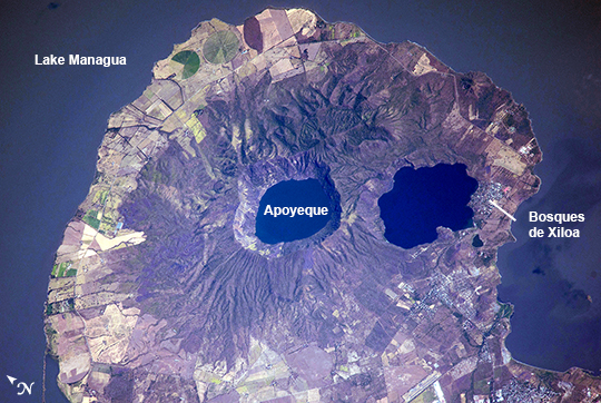 |
| Apoyeque Volcano, Nicaragua Note: This caption refers to the image versions labeled "NASA's Earth Observatory web site". The Chiltepe Peninsula, highlighted in this astronaut photograph from the International Space Station, extends into Lake Managua in west-central Nicaragua. The peninsula is formed from part of a large ignimbrite shield, a geologic structure created by deposition of primarily low density materials (such as pumice) ejected during violent, explosive eruptive activity. Ignimbrite deposits are most commonly emplaced during large pyroclastic flows - gravity-driven mixtures of rock, ash, and volcanic gases that can cover 100s of kilometers at speeds of 100s of kilometers per hour - with ignimbrite shields formed over geologic time by successive flows. The Apoyeque caldera, filled with a 2.8 km wide and 400 meter deep lake, dominates the center of the peninsula. Geological evidence indicates that Apoyeque last erupted around 50 BCE (plus or minus 100 years). The Laguna Xiloa maar - a volcanic crater formed by the explosive interaction of magma and groundwater - is located immediately to the southeast of Apoyeque and is also filled with a lake. Laguna Xiloa last erupted approximately 6100 years ago. More recently, a swarm of small earthquakes was detected near Apoyeque in 2012. These seismic swarms, when detected in volcanically active areas, may indicate movement of magma prior to an eruption. The capital city of Managua, not visible in the image, is located approximately 15 kilometers to the southeast of Apoyeque, while the town of Bosques de Xiloa is considerably closer (approximately 4 km). |
| Images: | All Available Images Low-Resolution 306k |
|
| Mission: | ISS038 |
|
| Roll - Frame: | E - 35123 |
|
| Geographical Name: | NICARAGUA |
|
| Features: | APOYEQUE VOLCANO,CHILTEPE PENINSULA,XILOA LAKE,LAKE MANAGUA |
|
| Center Lat x Lon: | 12.2N x 86.3W |
|
| Film Exposure: | N=Normal exposure, U=Under exposed, O=Over exposed, F=out of Focus |
|
| Percentage of Cloud Cover-CLDP: | 10 |
|
| Camera:: | N4 |
|
| Camera Tilt: | 30 | LO=Low Oblique, HO=High Oblique, NV=Near Vertical |
| Camera Focal Length: | 1000 |
|
| Nadir to Photo Center Direction: | N | The direction from the nadir to the center point, N=North, S=South, E=East, W=West |
| Stereo?: | Y=Yes there is an adjacent picture of the same area, N=No there isn't |
|
| Orbit Number: | |
|
| Date: | 20140121 | YYYYMMDD |
| Time: | 161505 | GMT HHMMSS |
| Nadir Lat: | 10.1N |
Latitude of suborbital point of spacecraft |
| Nadir Lon: | 86.9W |
Longitude of suborbital point of spacecraft |
| Sun Azimuth: | 139 | Clockwise angle in degrees from north to the sun measured at the nadir point |
| Space Craft Altitude: | 225 | nautical miles |
| Sun Elevation: | 51 | Angle in degrees between the horizon and the sun, measured at the nadir point |
| Land Views: | CALDERA, CRATER, PENINSULA, VOLCANO |
|
| Water Views: | LAKE |
|
| Atmosphere Views: | |
|
| Man Made Views: | |
|
| City Views: | |
|
Photo is not associated with any sequences | ||
| NASA Home Page |
JSC Home Page |
JSC Digital Image Collection |
Earth Science & Remote Sensing |
|
This service is provided by the International Space Station program and the JSC Earth Science & Remote Sensing Unit, ARES Division, Exploration Integration Science Directorate.

|