Geographic Region: BOLIVIA
Feature: SALAR DE COIPASA, SEDIMENT, LAGO COIPASA
|
Geographic Region: BOLIVIA Feature: SALAR DE COIPASA, SEDIMENT, LAGO COIPASA |
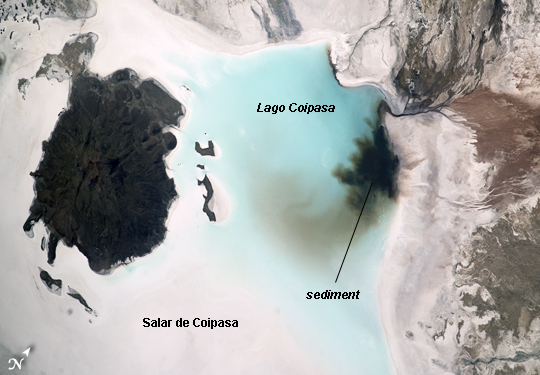 |
| Salar de Coipasa, Bolivia Note: This caption refers to the image versions labeled "NASA's Earth Observatory web site". The Salar de Coipasa, located in the Altiplano region of western Bolivia, covers an area of approximately 2500 square kilometers. The word "salar" describes arid closed basins in which evaporation of mineral-rich waters leads to the formation of thick, flat-laying salt deposits. Salar de Coipasa is located to the southwest of the saline Lake Poopo and northwest of the largest salt flat in the world, Salar de Uyuni. At Coipasa, a crust composed of halite--common table salt--provides the brilliant white coloration characteristic of the Altiplano salars (image left). While the environment of Salar de Coipasa is arid, it does receive constant water from the Lauca River flowing from the north; this feeds Lake (Lago) Coipasa that fills the northern end of the basin with shallow water (image center). However, the water flow can drop off sharply during periods of drought. The waters of Lake Coipasa, and the white salt crust of the salar, also serve to highlight dark river sediments flowing into the basin along the northeastern shore. Dark volcanic rocks contrast sharply with the surrounding salt crust at image left. While the western Andes mountains contain many active volcanoes, the nearby Tata Sabaya volcano (not shown) has not been historically active. |
| Images: | All Available Images Low-Resolution 170k |
|
| Mission: | ISS033 |
|
| Roll - Frame: | E - 6202 |
|
| Geographical Name: | BOLIVIA |
|
| Features: | SALAR DE COIPASA, SEDIMENT, LAGO COIPASA |
|
| Center Lat x Lon: | 19.3S x 68.1W |
|
| Film Exposure: | N=Normal exposure, U=Under exposed, O=Over exposed, F=out of Focus |
|
| Percentage of Cloud Cover-CLDP: | 10 |
|
| Camera:: | N5 |
|
| Camera Tilt: | 37 | LO=Low Oblique, HO=High Oblique, NV=Near Vertical |
| Camera Focal Length: | 400 |
|
| Nadir to Photo Center Direction: | W | The direction from the nadir to the center point, N=North, S=South, E=East, W=West |
| Stereo?: | Y=Yes there is an adjacent picture of the same area, N=No there isn't |
|
| Orbit Number: | |
|
| Date: | 20120920 | YYYYMMDD |
| Time: | 174658 | GMT HHMMSS |
| Nadir Lat: | 18.1S |
Latitude of suborbital point of spacecraft |
| Nadir Lon: | 65.5W |
Longitude of suborbital point of spacecraft |
| Sun Azimuth: | 307 | Clockwise angle in degrees from north to the sun measured at the nadir point |
| Space Craft Altitude: | 230 | nautical miles |
| Sun Elevation: | 61 | Angle in degrees between the horizon and the sun, measured at the nadir point |
| Land Views: | BASIN, SALAR |
|
| Water Views: | LAKE |
|
| Atmosphere Views: | |
|
| Man Made Views: | |
|
| City Views: | |
|
Photo is not associated with any sequences | ||
| NASA Home Page |
JSC Home Page |
JSC Digital Image Collection |
Earth Science & Remote Sensing |
|
This service is provided by the International Space Station program and the JSC Earth Science & Remote Sensing Unit, ARES Division, Exploration Integration Science Directorate.

|